

Everyone wants accurate weather predictions, but for the military, and the Navy in particular, they can be crucial — typhoons can sink ships and bad weather can force operational delays.
Providing timely and accurate weather predictions and information about the maritime environment falls to the roughly 2,500 military members and civilians who work for the Naval Meteorology and Oceanography Command.
“Naval oceanography applies meteorological, oceanographic and astrometric decision-science expertise across every aspect of warfare,” said Rear Adm. John A. Okon, who heads the Stennis Space Flight Center, Mississippi-based command. “No other organization across our government, [including] the Department of Defense, applies this knowledge under, on or above the sea in a manner with assured information that can be protected and relied upon in the high-end fight.”
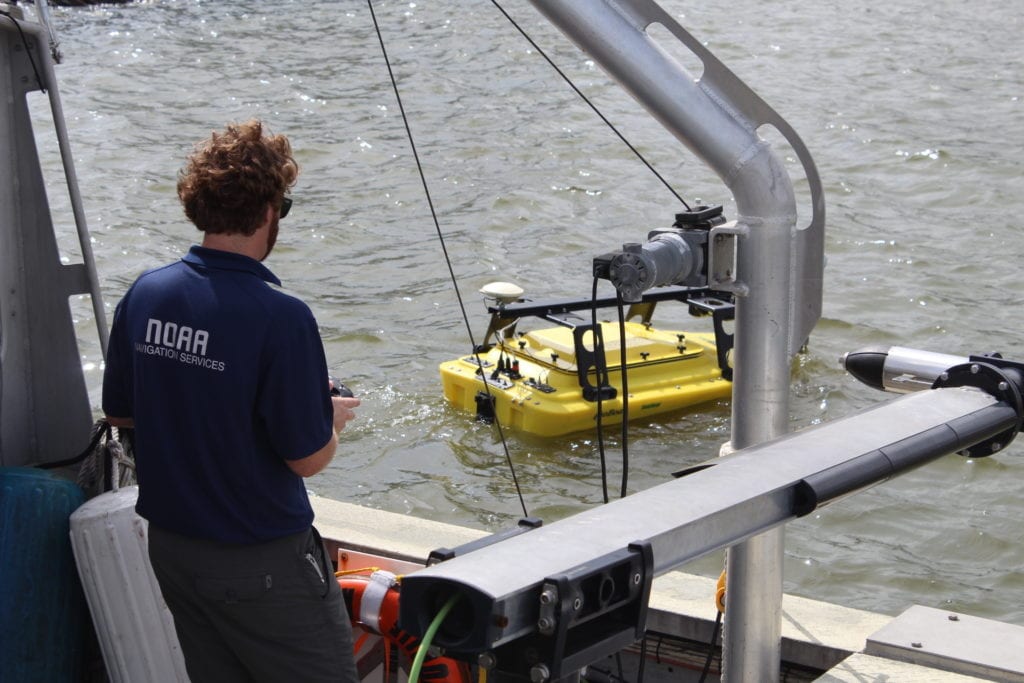
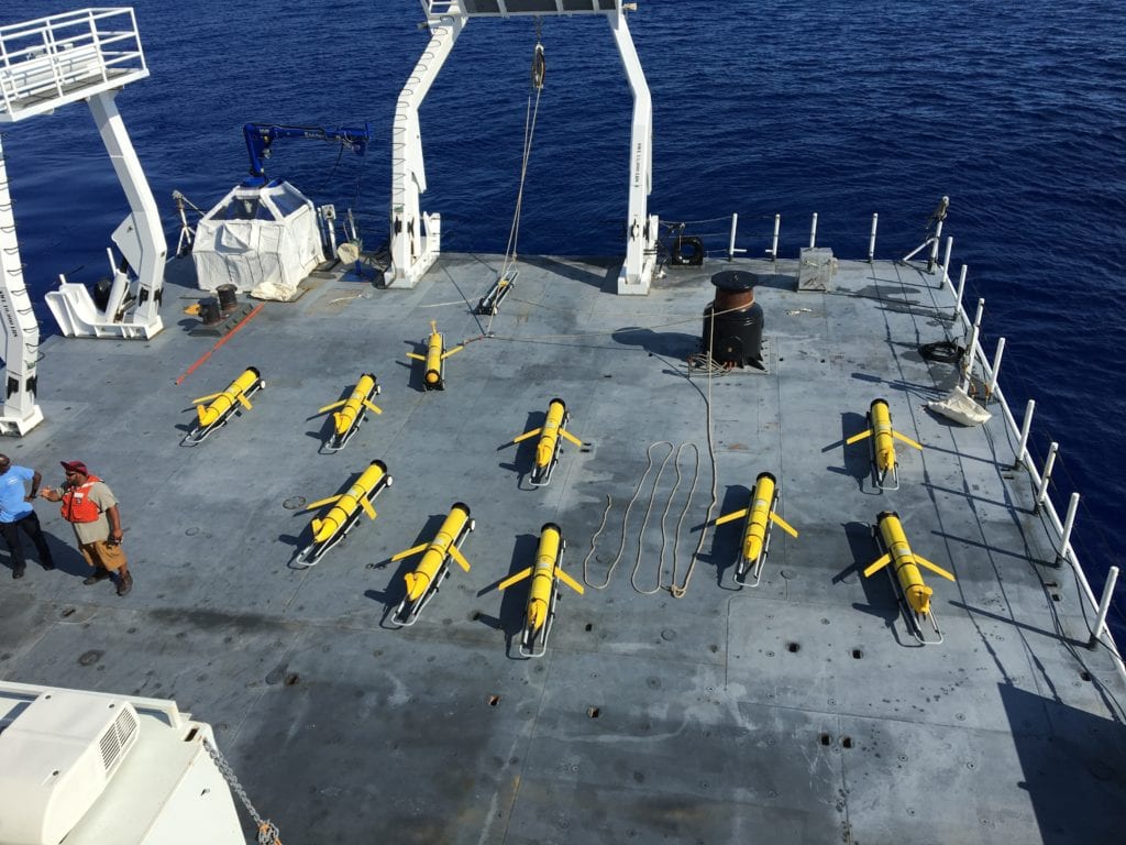
The Navy’s antisubmarine, mine, electromagnetic and special warfare communities all depend upon information the Naval Oceanography Operations Command — which reports to Okon — gathers and processes. Six Pathfinder-class (T-AGS) survey ships and a fleet of unmanned underwater vehicles operate while forward deployed, constantly compiling data.
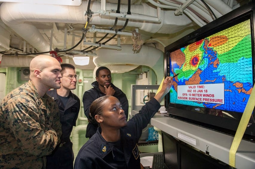
Buoyancy gliders, drifters, upper-air balloons, satellites and telescopes monitor the operational space from the ocean floor to the stars, providing commanders with real-time understanding of the conditions in which they conduct their missions. The data is processed into numerical models that forecast conditions of the atmosphere, ocean, waves, ice and surf as accurately as possible — and predict how they would affect the performance of weapons systems and fleet operations.
“We use high-performance computing to match with the expert knowledge of our Sailors and civilians — subject matter experts — to develop various certain scenarios that might affect fleet operations,” Okon said.
For example, a typhoon moving through the Western Pacific would certainly curtail surface-fleet operations, Okon said, but offer optimal conditions to conduct antisubmarine warfare. “This is a critical tier that develops environmental knowledge and a predictive advantage to the fleet.”
Round the Clock Forecasting
The Fleet Numerical Meteorology and Oceanography Center (FNMOC) engages in round-the-clock, high-performance computing at all levels of security, from unclassified to top secret. “FNMOC has the nation’s only information-assured modeling capability,” Okon said.
Fleet weather centers at Norfolk and San Diego naval stations can take information from both the Oceanography Operations Command and FNMOC and provide operational area forecasts to the fleet as it is in route, Okon said. Even though such actions ensure a margin of safety, Okon pointed out that “Mother Nature always gets a vote.”
The cooperative effort among the production centers and the fleet weather center provides further information that would keep the forces of nature from wreaking havoc on a mission, Okon said. Additionally, the U.S. Naval Observatory in Washington, D.C., provides the authoritative time reference essential for precise navigation and positioning necessary for accurate computer operation, as well as targeting of weapons and systems.
Okon described the concept of battlespace on demand as a multi-tiered pyramid. The bottom layer consists of observational platforms, with eyes on the oceans, the atmosphere and space. The next tier employs models generated from those observations, providing a functional understanding and prediction of any given environment. The top layer, he said, uses the collected information to determine how the environment would affect performance of forces and systems.
Ultimately, Okon said, the highly trained Sailors and civilians who work under him are experts in disseminating the data and providing the fleet with the predictive advantage they need. The work at hand requires what he calls a highly trained and motivated staff of apprentice, journeyman and master forecasters. “They’re the ones who link the data to decisions,” Okon said.
Much of his enlisted force consists of 975 aerographer’s mates. Some 340 officers are oceanographers, the senior-most of whom hold masters’ degrees in meteorology.
“We also have civilians who have dedicated their lives to this cause — naval oceanography — to predicting the physical battle space,” Okon said.
As technical lead for the command’s acoustics department, civilian Joseph Senne evaluates the effects on the environment as sound travels through water and into sediment. Any naval craft — manned, unmanned, surface or subsurface — will be affected, he said.
“We estimate geologic properties so that fleet systems give more accurate predictions of how acoustics interact with the seafloor as they’re moving through different world areas,” said Senne, a physicist who holds a doctorate in ocean engineering and master’s degree in marine science. While the general approach to the job is not new, Senne said, the work constantly changes as computers become more capable.
Senne and his colleagues work with other organizations in the Navy research community, including the Office of Naval Research (ONR), the Naval Research Laboratory (NRL) and the warfare development centers.
“We’re more the production piece, making sure that the answers we’re providing around the world are interacting with tactical decision aids and giving correct answers,” Senne said.
The different parts of the ocean change constantly, he said. Salinity, temperature and the water column itself all have an effect on the way sound travels.
“The cutting edge is being able to keep track of the spatial and temporal variability of the water column, as well as taking advantage of new technologies and methodologies to describe the geo-acoustic environment,” Senne said. “Sound that hits rocky outcroppings is going to behave very differently than when it’s hitting mud.”
Getting this information disseminated and delivered to the captain of a vessel can influence critical decisions. Correct information would better enable a sensor to accurately indicate that an object is one specific distance away or moving in one particular direction. Senne and his colleagues are called upon to spend considerable time at sea plying their trade, with productive results.
“We have mounted sensors on our ships that are multi- beam bathymetry and sub-bottom profiling measurement systems,” Senne said. “They’re putting out sound at very specific frequency bands.”
Based on how the sound reflects off of the sediment, the angle at which it is emitted and returned and travel time, shipboard crews can determine the depth of the water in which they are operating.
“We can do that at very high resolutions and are able to map out the seabed itself,” Senne said. “On top of that, on our acoustic surveys, we will trail seismic-type equipment behind us that is putting sound deeper into the sediment so that it’s not just reflecting from the water-sediment interface but from the layer interfaces of the sediment as well.”
Relaying the Message
The command’s Sailors have to be proficient in jobs that require mastery of a complicated skill set and explain its relevant points to people in leadership who must use them to take critical action at a moment’s notice. Chief Aerographer’s Mate Ciera Greene, an instructor at the Fleet Anti-Submarine Warfare Training Center at Point Loma, California, embraces the challenge.
“It’s super rewarding to have your products be valued at such a high level, and [to be] talking directly to the people making decisions,” Greene said. To be effective, Greene at times has to engage in jargon-filled discourse with her professional colleagues.
“When we’re going through our schooling, we are learning the parameters and rules and science of it all in depth,” Greene said.
But relaying relevant information to those who need it requires a different skill set that also must be learned, Greene said.
“When we talk to other people, we want to explain how we got our answers in definiteness [and] build our credibility,” Greene said. “When a weather briefing is due, you have to understand what everyone is thinking about, the things that matter and the things that could help. And you tailor your briefing to that.”
Bogging down presentations with technical jargon could mean a missed opportunity to inject a valuable piece of information into the decision-making process. The meteorological and oceanographic community, Greene said, uses data from its models primarily provide a level of safety.
“To be a part of the mission in a way that can only make it more efficient and effective is huge,” Greene said. “I’m very proud to be a part of it.”
As quick as Okon is to recognize the contributions civilians and Sailors like Senne and Greene, he understands that continued success hinges upon cooperative arrangements that extend both with and beyond the Navy com- munity. Partnerships with government agencies like the National Oceanic and Atmospheric Administration, and cooperative research and development agreements with industry, are essential to speed emerging technology through the production pipeline and deliver it to forward operators.
“It is a very big deal. These are key challenges for us, in under and on the sea,” Okon said.
Arrangements such as the command’s two-decade partnership with the University of Southern Mississippi and the Defense Advanced Projects Research Agency, as well as ONR and NRL, are producing results, Okon said.
“The Gulf Coast Tech Bridge Network spans from Talla- hassee to Panama City [Florida], to Stennis Space Center[in Mississippi], to New Orleans,” Okon said. “It’s a collaboration of three Navy commands — mine, the Naval Surface Warfare Center Panama City Division, and the Naval Research Laboratory at Stennis, and it serves as the nation’s regional super connector — tying together government, industry and academia to solve the Navy’s and nation’s challenges in coastal regions.”
International partners also play essential roles, Okon said, by providing vital oceanographic data and access to ports and harbors around the world. The collective effort, he said, is vital in countering the power competition and thwarting the illegal drug trade.
Unmanned Expertise
Additionally, the oceanography community is emerging as a Defense Department leader in the operation of unmanned vehicles, Okon said.
“We are a key component of the Navy’s innovation culture of catalysts, and we must outpace our competition to ensure that U.S. forces retain that technical warfighting advantage,” Okon said.
With more than 20 years’ experience in operating some 100 different unmanned systems, Okon said, only the commercial oil and gas industry has been at it longer. The command has operated these systems in every ocean in the world and has what he described as a significant inventory of vehicles that have logged more than 60,000 miles and 19,000 hours of bottom time in nearly 2,000 sorties.
“We are the only organization in the world to successfully deploy, operate and retrieve the most ocean gliders at one time — more than 100,” Okon said. “We did that from one location, right here at Stennis.”
The combination of human talent and cutting-edge assets, Okon believes, place the oceanography community in a prime role for the continuing effort to maintain freedom of the seas and win wars.
“Wherever the Navy or joint maritime force is,” Okon said, “you will find naval oceanography.”


- Panelists: Tackling Challenges, Building Trust Will Proliferate Unmanned Capabilities - April 5, 2022
- Space: The Next Warfighting Domain - April 5, 2022
- Partnerships Key to Confronting Adversaries, Harker Says - August 4, 2021
