Ships and Human Performance: Surface Forces Take Holistic Approach to Sailors, Crew Training
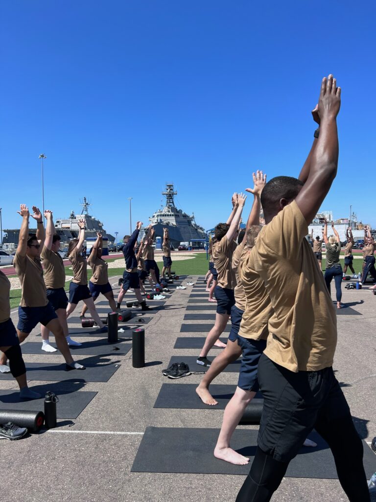
Human performance company O2X led littoral combat ship crews in two days of exercise and yoga classes during a workshop in San Diego in late 2021. U.S. NAVY
On the surface of it, the idea of training Sailors about nutrition, exercise, fitness, injury prevention, sleep and mental well-being didn’t seem like a hard sell. Two days of classroom instruction, workout drills and yoga sessions, all led by professional trainers, gave them a temporary break in their routine aboard ship in homeport at Naval Base San Diego.
The workshops led by O2X Human Performance over the past year are an outgrowth of an innovative program that began in 2021 at Surface Warfare Officers School to teach future ship commanders how to better lead their crews by maximizing their own work performance, physical fitness, mental health and mental readiness. The holistic approach to these programs are among the surface Navy’s continuing course changes after investigations into the causes of shipboard mishaps, including collisions and groundings, found commanders and crews plagued by sleep deprivation, stress, fatigue and inadequate training.
The initial series of workshops for ships’ crews — supported by Naval Surface Force officials in concert with Naval Health Research Center’s Crew Readiness and Watchstanding (CREW) efforts — found that all Sailors benefit from the training and incorporated it into their own work and personal lives.
“We’ve collected a substantial data. It’s loved. Everybody likes it,” said Dale Russell, the Naval Surface Force’s operational safety and human factors advisor in San Diego.
As of mid-October, 770 Navy personnel have gone through the O2X program since it was incorporated into the Prospective Commanding Officer/Executive Officer courses at Surface Warfare Officer School in Newport, Rhode Island, according to O2X Human Performance, a Scituate, Massachusetts-based company founded by three former Navy SEALs. That includes 440 officers at SWOS and 305 sailors and officers from Naval Surface Forces Pacific ships in San Diego, including destroyer USS Preble (DDG 88), littoral combat ship USS Manchester (LCS 14) and, more recently, the Blue Crew of USS Omaha (LCS 12).
Buoyed by the positive feedback, Naval Surface Force is weighing the next step and plans to expand its investment across the waterfront by developing a program in-house. Consider it the human equivalent of preventative maintenance measures the Navy long has had in place for its multi-billion-dollar inventories of ships and aircraft.
Preventative Maintenance
It would be “an O2X-like program that is organic to the fleet and is built around firefighting and damage control,” Russell said. “It will give the team something to rally around. It’ll build unit cohesion, solidarity, camaraderie… [and] it’ll give them a context to get into physical shape. This will give them something to train around.”
An ongoing CREW study, into wearables for fatigue management, is helping get “this curriculum in front of as many Sailors, leaders and surface fleet that we possibly can,” said Adam La Reau, a former SEAL and co-founder of O2X Human Performance. Sailors “are excited that the Navy is putting the time into them.
“We’re providing skills-based training. That education, just like with their skills-based training with the jobs that they do every single day, continues,” La Reau said. “Human performance is no different than [training] in their roles as a navigator. They constantly have to learn.”
“This is not something that you provide one time,” he said. Ideally, “they have to be built into their routine, built into their battle rhythms, but also at touchpoints. These are hard installs of education along the way. It could be when a ship is coming out of a maintenance cycle. It could be at Great Lakes, post-A School. It could be periodically when a ship crew change-out happens.”
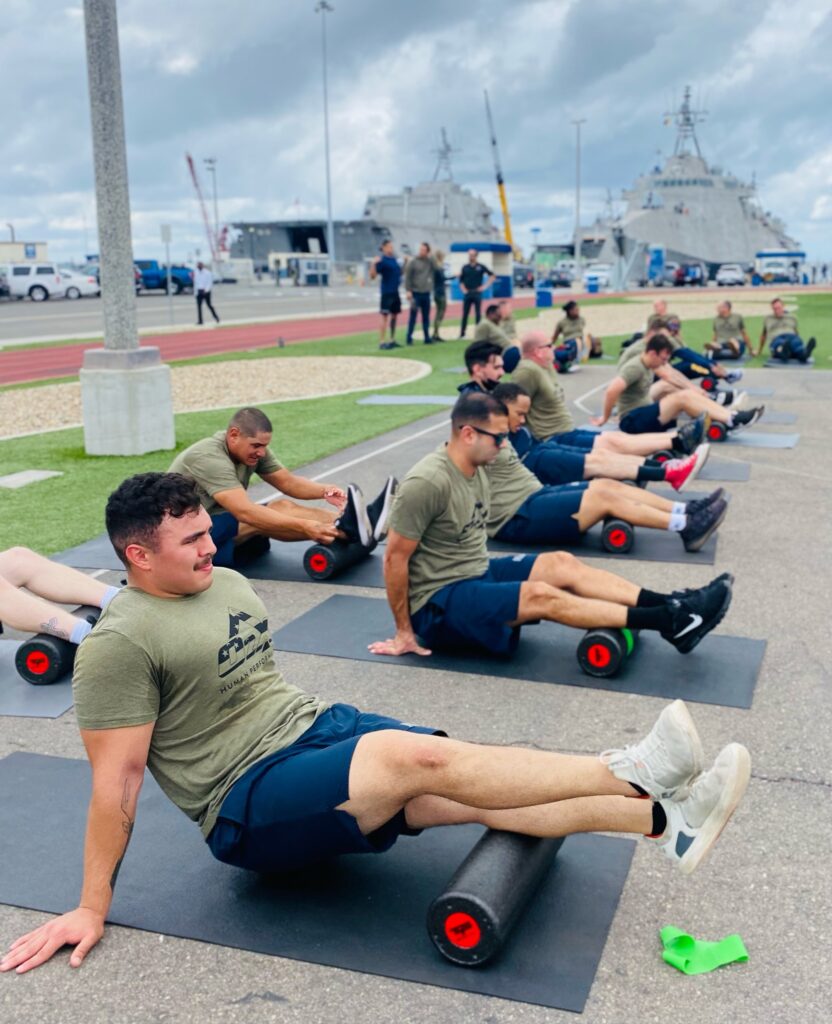
The O2X classes are an outgrowth of a program that began in 2021 at Surface Warfare Officers School to teach future ship commanders how to better lead their crews by maximizing their own work performance and physical fitness. U.S. NAVY
O2X’s mantra focuses on one making small but important incremental changes of 1% — whether in sleep or nutrition habits, managing stress or exercise routine. Each workshop wraps up with an all-hands discussion on making that goal a daily reality. “It’s not just with the leaders, it’s with the entire crew and teaching them about taking ownership,” La Reau said.
“It’s like everyone’s on a team, and you’re walking into a locker room every single day and we continue to fill each other up. We find ways as an organization, not necessarily waiting for the CO or the XO or one of the senior enlisted to step up and say something. Everybody has a voice here,” he added. “The Sailors have a ton of examples of previous ships and past experiences that may be small things that we could potentially change. We don’t have to do it the way we’ve always done it.”
O2X Human Performance is working with Naval Health Research Center over the next year in the CREW study and with the Navy’s Center for Security Forces and is talking with aviation and safety commands for potential collaboration in similar vein as the fleet.
“There’s quite a bit of appetite and opportunity,” La Reau said, noting the training touches on safety, health, wellness, readiness, resilience, retention and maybe recruitment. “There’s also a risk-mitigation factor here. It’s driving self awareness. It’s understanding what your capabilities are, understanding … how to persevere through challenging times or in the moment to be able to dig into resources to execute at a very high level.”
The best part, he said, is “we’re seeing these individuals saying, ‘I need to make a change. Me being a good leader is definitely tied to taking care of myself and me being a good example. Especially onboard a vessel, onboard a ship. People are emulating what I do and how I live my life. I need to take care of myself, so I can take care of my ship and my Sailors and so I can be the best leader that I can be. And I can do the things that the country has asked me to do.’”
Naval Surface Force and Naval Health Research Center continue to process and analyze feedback and data collected through the workshops’ participants who use wearable devices that track sleep, exercise and other information. “The scientific literature is pretty clear: If you exercise, your biophysical response makes you sleep better, which gives cortisol, which makes you feel better. It builds social bonds, which make you feel better, sleep better, exercise better,” Russell said. “So, it’s a positive feedback loop.”
The reality of daily life in the fleet, however, makes physical training extremely hard for many Sailors and crews to sustain, he acknowledged. But Sailors want just that. In safety climate assessments across the fleet, collected as part of the CREW effort over the last two years, “Sailors have voiced: We really want to work out more. We’re bummed that we don’t have group PT,” Russell said. “A very small percentage of the ships even have mandatory PT, because of the nature of the environment they work in. We’ve realized that a paradigm shift is needed, but that’s easier said than done in a large organization like ours.”
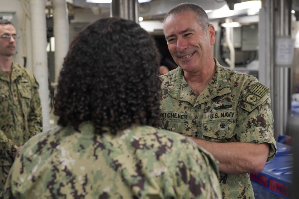
Naval Surface Force officials, led by Vice Adm. Roy Kitchener, are working to change that. As it develops its organic human performance training, the surface Navy also will roll out a new watchbill software, OWL, designed to help leaders and crews manage fatigue.
“We are right now pilot-testing that on, I think eight ships this fall, currently. If this works out, then we’ll start rolling it out to the fleet next year, fleetwide,” Russell said. “We are getting ready to rewrite our CREW Endurance instruction to capture that.”
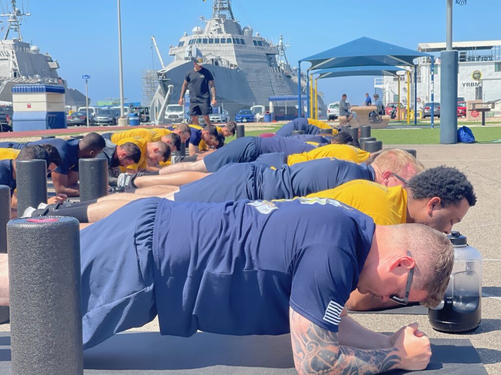
Buoyed by positive feedback, Naval Surface Force plans to expand its investment across the waterfront by developing a similar program in-house. U.S. NAVY
Wearable Devices
SURFOR also is looking at using wearable devices as “an occupational management” tool, he said, provided they can develop algorithms that work for shipboard life. Trackers such as Fitbit work if one is “walking on terra firma, not on water, which throws off some of the sensors on it,” he said. With 18 months of data collected so far, SURFOR is “putting motion sensors aboard the ships so we can kind of get a feel for how a ship like an LCS bobs in the water as opposed to an amphib, so we can tweak the algorithm based on whatever ship they’re on.
“The plan will be to roll out 55,000 wearables to the entire fleet,” he said, acknowledging the challenge since one-third of a ship’s crew turns over annually. More likely those devices would be fielded to field it to “key, critical billets,” likely the bridge, engineering and combat information center.
Several months ago, Kitchener allocated $1 million for the authority to operate “a wireless hub to go on ships and pull the data off the wearables to the ship’s network — CANES — and feed it into OWL,” Russell said. If all goes as planned, that connectivity will be up and running on those ships during exercise Talisman Saber in 2023 “so we can kind of pressure-test it.”
“OWL will give the leadership on the ship that visibility of what’s going on. … They can break it down by department, watchbill, however they want to slice and dice that data,” he said. Connectivity can be spotty at sea, so they’re looking to push data off the ship and into Jupiter, the Navy’s enterprise data link environment. The combination of OWL implementation and wearables could provided a “check engine,” light, for example, for someone who didn’t sleep well at night.
“That could the touchpoint” for a leader to then ask them to go see medical or ask about their sleep, Russell said. “So no matter – whether you have COVID or whether you haven’t slept well or you had a fight with your loved one or you’ve got an STD — it’s your heart-rate variability and deviation from that. … We’re just trying to trigger that touchpoint and say, something’s wrong. Let’s go see what might be wrong.”
Capt. Shea S. Thompson Commodore, Surface Development Squadron One (SURFDEVRON 1)
Capt. Shea S. Thompson. U.S. NAVY
A native of San Marcos, California, Thompson received his commission from the U.S. Naval Academy in 1997. His sea tours included USS George Philip (FFG 12), USS Cape St. George (CG 71), and USS John Paul Jones (DDG 53). He served as executive officer and then commanding officer of USS Chafee (DDG 90). Subsequently he commanded USS Bunker Hill (CG 52).
Thompson’s tours ashore include Naval Postgraduate School where he earned a Master’s Degree in Financial Management; Ballistic Missile Defense Syndicate Lead at Tactical Training Group Pacific; Ballistic Missile Defense Training Officer at U.S. 3rd Fleet; Joint Interface Control Officer at Headquarters U.S. European Command (J3); C4ISR Operations Branch Chief at U.S. Strategic Command, Joint Force Component Command Global Strike (J6); N8/9 Branch Head Headquarters Surface and Mine Warfare Development Center.
Thompson discussed the roles of Surface Development Squadron One with Senior Editor Richard R. Burgess. Excerpts follow.
How did your background prepare you for your current command?
THOMPSON: Actually, my background prepared me quite well. Following my command tour on USS Chafee, I had the privilege of being assigned to the Surface and Mine Warfighting Development Center [SMWDC] where I served as N8/9 Branch Head for Future Requirements & Resources and Experimentation from 2016 to 2019. During that time, I had significant exposure to the acquisition and budgeting process as well as requirements generation. SMWDC’s Warfare Improvement Programs fell under my portfolio for those three years. We produced the surface fleet’s Integrated Prioritized Capabilities List for surface warfare Integrated Air and Missile Defense, Surface Warfare, Amphibious Warfare and Mine Warfare. That experience really benefited me as I became intimately familiar with the capability gaps across all those mission areas.
I’ve worked with a number of stakeholders to include the technical community on how we would get at closing those gaps and back in 2017, we recognized unmanned systems had a role to play in closing a number of gaps across those mission areas. The beauty was, as I also wore the N9 hat, I was able to partner with industry and experiment with new and innovative capabilities that helped close those gaps. For example, I personally worked closely with industry on the first-ever remote operation of Sea Hunter [unmanned surface vessel] from a surface combatant to validate that capability. So, the learning curve of employing and operating unmanned platforms with and from manned surface forces wasn’t that steep for me as I came into this job.
In fact, when I took command of SURFDEVRON, I was encouraged by the progress I saw had been made since my time in SMWDC and my time taking command here. We’ve come a long way since 2017 [with] the current and future capabilities and possibilities that exist with manned and unmanned teaming, how that will enhance the lethality of the surface force going forward.
How many personnel comprise your command?
THOMPSON: On staff here at SURFDEVRON I have 13 Officers, 58 enlisted, and one civilian permanently assigned. USS Michael Monsoor (DDG 1001) and USS Zumwalt (DDG 1000) each muster about 180 personnel. Obviously, I’m eagerly awaiting delivery of USS Lyndon B. Johnson (DDG 1002) when that day comes. USV Division 1 was formally established during the SURFDEVRON 1 change of command ceremony on May 13 and is now commanded by CDR Jerry Daley. That squadron has actually grown to 103 Sailors comprised of 12 officers and 91 enlisted. Those folks are there to provide dedicated support to USV operations.
Cmdr. Jeremiah Daley, commanding officer, Unmanned Surface Vehicle Division One, Secretary of Defense Lloyd J. Austin III and Capt. Shea Thompson, commodore, Surface Development Squadron One, tour USV Sea Hunter at Naval Station Point Loma, California, Sept. 28. DOD / Chad J. McNeeley
How has the Chief of Naval Operations’ new Navigation Plan influenced the focus of your work?
THOMPSON: The CNO’s Navigation Plan is the guiding framework for my efforts for USV experimentation and fleet integration. In there, it talks about [how] unmanned surface platforms will increase the fleet’s capacity for distribution and expand our intelligence, surveillance and reconnaissance advantage, add depth to our missile magazines, supplement logistics, and enhance fleet survivability. This transition will gradually rebalance the fleet away from exquisite manpower-intensive platforms for smaller, less expensive yet lethal platforms. The capacity goal, if I remember correctly, is approximately 150 USVs.
That plan also emphasizes the importance of the manned/unmanned teaming in future fleet operations. We’re really getting at that. For example, one of the concepts we’re working on is further distributing the force through manned and unmanned teaming. Your typical surface action group, or SAG, consists of three destroyers. Right now, we’re trying to reimagine that traditional SAG. Instead of three manned DDGs making up that SAG, we’re exploring options to have one DDG as the center of a SAG teamed up with a number of unmanned surface vessels that would be one SAG. That also frees up the other two destroyers to create other manned/ unmanned SAGs and further distribute the force and enhance the capability and lethality of those SAGs as well. Honestly, I envision a future where this is the standard SAG construct and my team here is moving out full speed on proving out that concept.
What kind of experiments have you been working on with the Zumwalt-class DDGs?
THOMPSON: I would say that for the class, it’s been less about experimentation and more about class capability validation. That’s not to say we haven’t been leveraging those platforms for experimentation efforts.
I know you’re aware that Zumwalt is currently employed in the Indo-Pacific region, and she is working on fleet integration and participation in fleet exercises. We’re pushing her forward to learn how the ship can best operate and integrate with other fleet assets and how this integration is done at the tip of the spear. You can only do so much learning pierside. It is important to accelerate her introduction into fleet exercises and this learning is going to inform future employment of the class. Prior to this employment, Zumwalt went through your standard workups for employment, conducting basic training certification events and participating in the Surface Warfare Advanced Tactical Training, otherwise known as SWATT.
Earlier this year, Monsoor participated in an ASW [antisubmarine warfare] exercise known as SCC Mini-wars, and she did that with coalition partners and the USV Sea Hawk in the Hawaiian op area. Monsoor also recently participated in the first RIMPAC exercise for the class where, again, she focused on force integration and continued her work with unmanned vessels in that exercise.
Do you expect the Zumwalt DDGs to return to your squadron after their modification with the Conventional Prompt Strike capability?
THOMPSON: They’re going to come back to me following deployment and they’re going to be with me for the foreseeable future. The future plans for the class remain in work. We are gathering data right know regarding Zumwalt’s current deployment and Michael Monsoor’s RIMPAC support. We’re going to leverage that data and lessons learned on any future deployments to include how to maintain and sustain the platform in an operational environment when deployed forward. I will say the best way to continue learning and validating the existing capabilities and TTPs [tactics, techniques and procedures] for the class is to keep them underway and employed, whether that’s with 3rd Fleet or 7th Fleet.
What kind of things are you doing with the two Overlord USVs and what are you planning in the future once the other two Overlord USV are on strength?
THOMPSON: All four of the USVs that I own right now were involved in RIMPAC: Sea Hunter, Sea Hawk, Nomad and Ranger. Their involvement in RIMPAC really helped determine and define how the capabilities of the unmanned fleet will integrate with our manned ships. RIMPAC was an excellent arena to showcase the USVs’ usefulness in electronic warfare, data collection and how warships can leverage USVs in the high-end fight. In every exercise we do from SCC mini wars to SWATT to RIMPAC, the objectives being accomplished form the building blocks of realizing the manned/unmanned concept. A USV tracking a submarine using its ASW payload or providing target-quality tracks to a surface combatant — think EW [electronic warfare] payloads, sensor suite, etc. — we’re proving the USV is value added in providing our warships with more flexibility in meeting the mission.
How about your experimentation with Sea Hunter and Sea Hawk USVs?
THOMPSON: They each bring different payloads and capabilities. And so, we’re working with those to further validate our concepts. For the broader unmanned campaign plan, Surface Development Squadron One is developing those concepts in the playbooks, in the TTPs and we’re doing that with other stakeholders. We’re not doing that in a vacuum. I see those concepts and TTPs playing in the potential surface battles of tomorrow. The prototype USVs are being heavily leveraged to validate these concepts and TTPs. When the program of record USV does come online, we can quickly transition it into fleet operations. The goal to me will be for them to be embedded into fleet operations to further distribute the force, provide manned warships with target quality tracks and, also, for adjunct magazines.
One important note I think is worth mentioning is we’re focused on autonomous USVs with a man-on-the-loop technology. That means that even though a USV may be in an autonomous mode while conducting a mission, it is always being monitored — including its health status — and at any time the man-on-the-loop, whether on board a ship or shore, can take direct control as required.
Are there any specific accomplishments you want to mention with regard to the USVs or the Monsoor in RIMPAC?
THOMPSON: Sea Hawk was out during the SCC Mini-Wars and did excellent work. She validated the value of her ASW payload. Not just here at the Echelon 5 level but all the way into the Echelon 2 level. In the near future, we’re participating in a fleet exercise that we’ll explore how that capability supports our expeditionary capability and the Marine Corps’ efforts on that front, too. The big ship-to-shore movement of USVs’ C2 [command and control] nodes, officially we’re working with PMS-406 to gain unmanned, unescorted, OTH [over the horizon] proof-of-concept testing.
For Monsoor, RIMPAC was really a test of the operational concepts and to gather insights about further employment for the class. She flexed her capabilities across all mission areas to include SUW, ASW, and air defense. She also conducted an experiment that consisted of launched employment and recovery of a UAV to enhance maritime surveillance. All four USVs that participated in RIMPAC demonstrated how they fit into the composite warfare commander concepts either attached to a destroyer or sent out on individual missions. It really helped to determine how the capabilities of the unmanned fleet integrate with our manned ships, with focus on ASW, EW, surface warfare, interoperability and transfer of control of those USVs between manned ships and ashore or vice versa.
Then-Cdmr. Shea Thompson gives remarks during the Surface Development Squadron One change of command ceremony in May. During the ceremony, Thompson relieved Capt. Jeffery Heames as commander Surface Development Squadron One. U.S. NAVY / Mass Communication Specialist 2nd Class Diana Quinlan
With the Navy developing the Next-Generation Destroyer (DDG(X)) and the Large USV, are you actively engaged in providing feedback for development of those vessels?
THOMPSON: Yes. As we worked fleet introduction for DDG 1000 class and the USVs, there are a number of lessons learned that can be applied to both the DDG(X) and LUSV, not just from a capability validation perspective but also from a maintenance and sustainment perspective. And so, those lessons are being shared across the enterprise. The LUSV program is in the prototyping stage while we develop and demonstrate the technology for critical subsystems, through a comprehensive land-based and afloat test program across HM&E [hull, mechanical and engineering], C2, autonomy, perception and integrated combat system aspects prior to moving into serial production. By the end of 2023, we expect to have seven USV prototypes operating under the direction of Surface Development Squadron One and that’s in partnership with PMS-406 and the USV Program Office.
USVs are planned to be the high-endurance adjunct [missile] magazine based on commercial designs built around the common missile launcher and combat systems. The initial capability will be to support both surface warfare and strike warfare, but I anticipate that being expanded and air defense as well. The six LUSV studies contracts were awarded in September of this year. Those contracts are going to help refine specifications and requirements to inform future LUSV detail design and construction.
What advances have you seen in unmanned operations technology and sustainment since your squadron was established?
THOMPSON: Since Surface Development Squadron One was established, the advances I am most encouraged by are, we’ve got much more confidence in safe autonomous operations. We’ve been out and operating with these platforms for a long period of time. That resiliency really translates to increased on-station time, our abilities to control from ship or shore or, again, transfer control from ship-to-shore and vice versa. The capabilities of the various payloads for USVs provide the operators and leadership the confidence that manned/unmanned teaming does, in fact, enhance the lethality of the surface force.
I really believe it’s a game-changing concept, not only for the future force structure but from a tactical, operational and strategic perspective. Those are the big differences I see from back in 2017 when I was just proving out that I can actually operate a USV from a destroyer to where we are today. I’ll tell you that with the USV prototypes, we’re rapidly expanding their participation in the exercises as well as conducting independent operations such as a recent missile test from an Overlord USV. The maturing fleet experimentation and testing program only serves to increase the fleet’s knowledge on USV integration and operational and infrastructure support requirements.
What do you see as the remaining challenges of deploying, operating, and sustaining USVs?
THOMPSON: Well, you know, we’re going to continue working to make the USVs more reliable and sustainable through experimentation, lessons learned, testing, evaluation and increased employment. You can’t learn when those things are pierside, so we got to keep pushing them out there. Every USV underway hour provides us additional data and learning opportunities that support the maturation of economy and reliability. I said that one of the encouraging things was an increased confidence level and the safe autonomous operations. We still have some work to do in that area. Obviously, COLREGS [International Regulations for Preventing Collisions at Sea 1972] remains a focus area for the program. Today, the autonomy and reliability conduct vessel avoidance for 1v1 [one versus one] COLREGS encounters. However, we’re still got some work to do in complying with the full scope of COLREGS. That’s the hierarchy of vessels, low visibility compliance, autonomous lights, autonomous sound signals, etc.
Making Space for Women Aboard Coast Guard Cutters Helps with Retention, Careers
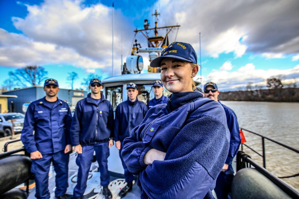
BM3 Hailey LaRue of the U.S. Coast Guard Cutter Wire in Saugerties, New York, in 2021. LaRue was able to serve on the Wire after Senior Chief Petty Officer Ramona Mason worked with service officials to create extra rack space. U.S. COAST GUARD / Daniel Henry
On June 1, the Coast Guard made history with the ascension of Adm. Linda Fagan to its top position as commandant, relieving outgoing commandant Adm. Karl Schultz. She took over as the first woman to head the Coast Guard and the first woman to head any U.S. military service.
Fagan arrived at that position at a time when there are still a few Coast Guard cutters afloat where women can’t serve due to a lack of rack space. That’s an issue the service has been working to eradicate for years and is on the cusp of doing so, a move expected to help boost women’s careers in the service and increase retention.
Of the service’s approximately 260 cutters, only 50 are male only, according to the Coast Guard, and those cutters are slated to be replaced. All new cutters coming online are able to accommodate male and female crewmembers.
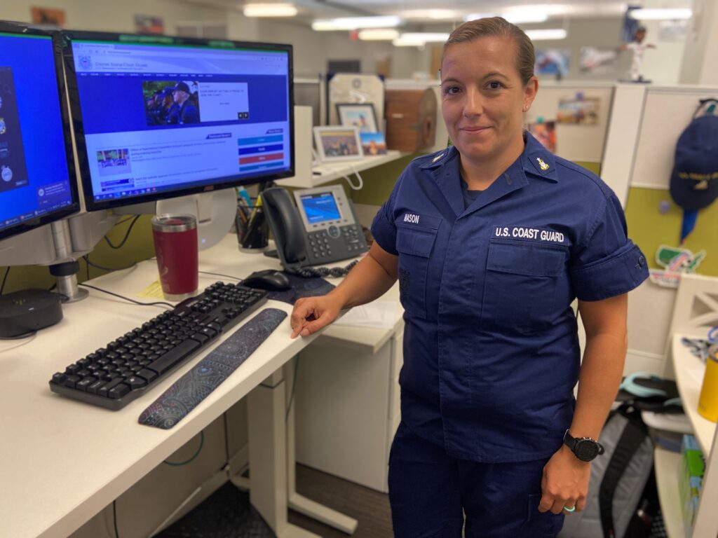
“With the modernization of our fleet, that will all be taken care of. All the newer cutters are being built with mixed crews on board in mind,” said Senior Chief Petty Officer Ramona Mason, the enlisted women afloat coordinator at Coast Guard headquarters in Washington, D.C. “All these new ones are already mixed-gender berthing.”
Even before all the cutters are ready, “We have gotten extremely creative, to create more opportunities for female enlisted members to serve underway,” she said.
“With all these creative ways that we have come up with, our afloat numbers for enlisted women afloat has gone up. We have way more females serving on afloat platforms now than we ever did before, and the numbers have gone up every year,” Mason told Seapower. “And it’s all because they are choosing, they wanted to go afloat. We’re giving them the opportunities now.”
“Today more women are remaining in our service longer,” Schultz said in his annual State of the Coast Guard speech in 2022. “Today we have 375 more women in the service at the critically important E6/E7 and O-4 mid-grade leadership ranks than we had five years ago in 2017… that’s a 28% increase of women at these mid-career pay grades, and a trend that outpaces their male counterparts.”
He also said the service is “making progress” on the acquisition of 30 Waterways Commerce Cutters, tenders that will maintain 28,000 aids that mark more than 12,000 miles of navigable inland waterways.
“And, for the first time in history, our entire inland fleet will be able to accommodate mixed-gender crews, providing all junior enlisted members these unique afloat experiences,” Schultz said.
President Joe Biden spoke at the Coast Guard change of command ceremony when Fagan took the service’s top spot.
“When Admiral Fagan commissioned in 1985, only five years after the first women graduated from the academy, she was one of just 16 commissioned female ensigns — only 8 percent of her graduating class. She was the only woman aboard Polar Star for the first set of orders,” Biden said.
“Currently, the Corps of Cadets at the Academy — more than 1,000 cadets strong — 40 percent are women.
Forty percent are women.”
Even as more women enter the service, keeping them there can be a challenge.
A recent study by the RAND Corp., “Why Do Women Leave the Coast Guard, and What Can Be Done to Encourage Them to Stay?” listed a variety of issues that answered the title question, among them the lack of berthing.
“Female focus groups cited issues with advancement, including the perception of bias in subjective evaluations, as influencing decisions. Furthermore, participants noted that berthing restrictions for women can limit opportunities,” the study says.
Mason said it’s important to provide as many afloat opportunities as possible to female Coast Guard members, as it can affect their career.
“Certain rates have requirements that you have to have a certain amount of years afloat, so it is a requirement for advancement. It’s a requirement for certain ratings or certain competencies that you can only earn afloat,” she said.
And while anyone in the Coast Guard can go afloat at any point in their careers, and are encouraged to do at least one tour afloat, “in order for advancement, in certain rates you have to receive the afloat time at a certain point in your career,” she said.
Making even smaller Coast Guard cutters able to accommodate mixed crews has other benefits that can aid in retention, Mason said.
“We’ve opened up a lot of the smaller cutters with enlisted females, which have always been in higher demand for the females due to the shorter underway time and the family life you can have when you’re only away for two to three weeks versus two to three months,” she said. “With us opening the smaller space to females, it has helped with retention, because they now see they can get under way on small platforms and not be such a family burden.”
Senior Chief Petty Officer Ramona Mason has worked to find rack space aboard Coast Guard cutters to enable women to serve on them. U.S. COAST GUARD / Richard J. Kolko
Making Room
Part of Mason’s job is to find room on Coast Guard cutters for women even if they aren’t designed with separate living quarters. She does that by sometimes repurposing space.
In a 2021 post to the Defense Visual Information Distribution Service, Chief Petty Officer Ryan Burger recounts how he got a call from Mason after he was appointed officer in charge of the Coast Guard Cutter Wire, a 65-foot ice-breaking tug. She asked if he could accept a female Boatswains Mate Third Class. He said yes. When she asked if he could accept another female as well, he said they had to do some work.
They ended up removing a convertible fold-out rack that had been used for executive petty officers and revamping it to hold two racks. They then proceeded to make a similar change to two other 65-foot cutters operated by Sector New York.
“We’ve assigned women to these cutters in command cadre positions in the past, however, assigning a third-class boatswains mate aboard is new,” Mason told writer Daniel Henry. “For the first time, a woman in a non-command position has received orders to the Coast Guard Cutter Wire.”
Petty Officer Third Class Hailey LaRue, a boatswains mate who was then able to serve on the Wire and reported there in the summer of 2020, said the move broadened the learning opportunities available to her, which wouldn’t have been possible on the 87-foot cutter she had served on previously.
“I knew I wanted to go afloat out of A-school to get rated sea time so that it would help me in my future career,” LaRue said. “It’s smaller and it’s a tight knit crew. There are tons of learning opportunities on both deck and engineering side so you’ll become a better-rounded individual in your [rating]. There are opportunities you’ll get here that you won’t necessarily get on a bigger cutter where you’re focused on a specific area.”
Vice Adm. Linda L. Fagan is promoted to the rank of admiral during a ceremony at Coast Guard Headquarters, June 18, 2021. Fagan is the Coast Guard’s first woman to serve as a four-star admiral. U.S. COAST GUARD / Lt. j.g. Pamela Manns
Cmdr. John Singletary, Chief of Waterways Management for Sector New York, told Henry, “providing this mixed gender berthing gives those members the opportunity to start their careers out early. They get to lead as a BM3 or a BM2. Eventually that path will lead to XPO positions on the new waterways commerce cutters that are being commissioned in late 2024.”
Not Just Afloat
The need to create berthing space for female Coast Guard members isn’t just for the water. In late September 2021, Coast Guard Station Morro Bay in California, part of Sector Los Angeles/Long Beach, made such an addition, according to the Coast Guard.
The station is home to 27 Coast Guard members and two 47-foot motor life boats. The station constructed a one-story, 806 square foot addition to the existing facility, creating room for up to six additional crewmembers and allowing overnight duty crews to be made up of men and women.
Women had been assigned to Morro Bay previously, but couldn’t always be accommodated for some of their duties due to a lack of berthing.
“We needed a dedicated accommodation for [women] and we now have that with the building expansion,” Petty Officer 1st Class Joshua Sheppard said in a My CG blog post. Women “can now be completely integrated as a member of the unit without being excluded from missions or opportunities and without posing a significant burden to the operational readiness.”
Mason wasn’t part of that effort — her duties extend only to women who serve afloat — and said the part of her job devoted to finding female berthing is coming to an end as the Coast Guard continues its modernization.
“The coordination part will go away, but the advocacy for women afloat will stay. My job is somewhat more transitioning into a women afloat career counseling position as well,” she said.
“I do year-round career counseling with all the females in the Coast Guard that are interested in afloat assignments,” working on resumes and timetables for them to go afloat, “when should they get underway, when do they have to get underway.
“So, the counseling part will stay around for the enlisted women of the Coast Guard.”
Hawaii-based Coast Guard Units Conclude RIMPAC 2022 Participation
A U.S. Navy Sailor directs Navy and U.S. Coast Guard Sailors to a U.S. Navy MH-60R Seahawk helicopter during flight operations during Rim of the Pacific 2022. U.S. COAST GUARD / Petty Officer 3rd Class Taylor Bacon
PEARL HARBOR — Four Hawaii-based Coast Guard units concluded operations contributing to the largest Coast Guard participation in the history of RIMPAC and returned to service of the residents of Hawaii and the Pacific region on Aug. 4, the Coast Guard 14th District said in a release.
U.S. Coast Guard Cutters Midgett and William Hart, the Pacific Dive Locker, and Maritime Safety and Security Team Honolulu partnered with military members from Australia, Peru, Republic of Korea, Canada, France and Japan throughout the in-port and at-sea portions of the Rim of the Pacific 2022, which ran from late June to early August. The exercise marked a series of “firsts” for Coast Guard participation.
Coast Guard Cutter Midgett conducted a broad spectrum of operations with the Japan Maritime Self Defense Force Ship Izumo, the USS Chafee, USS Gridley, French Navy Frigate FS Prairial, and Peruvian Navy BAP Guise. The combined team of Midgett, William Hart, Izumo and USS Essex completed RIMPAC’s first mass rescue operation, successfully partnering to find, recover and provide medical assistance to 10 simulated people in the water.
Following RIMPAC, Midgett’s crew will depart on a western Pacific patrol to build on the regional partnerships demonstrated here and conduct international training and fisheries law enforcement. William Hart’s crew will conduct necessary maintenance, complete training, and resume their role as a standby search-and-rescue asset for vessels in distress in the waters around Hawaii, a role it shares with the other two fast response cutters in Honolulu, Cutter Joseph Gerczak and Cutter Oliver Berry.
This year’s RIMPAC featured the first Coast Guard-led humanitarian assistance and disaster relief exercise. The exercise tested reopening a harbor that had been struck by a simulated hurricane. A boat crew from Coast Guard MSST Honolulu partnered with underwater survey teams from the U.S. and Royal Australian Navies to conduct underwater scans of Honolulu Harbor to identify hidden hazards. After that, divers from the Coast Guard Pacific Dive Locker collaborated with divers from the U.S. Army and Republic of Korea Navy to remove the hazards and practice maintaining aids to navigation underwater.
Following RIMPAC, the Pacific Diver Locker will focus on training and preparations for annual safety inspections and provide support to local Coast Guard assets and aids to navigation missions.
“This was an incredible opportunity to work alongside our partners in the Blue Pacific to strengthen our relationships,” said Coast Guard 14th District Commander Rear Adm. Michael Day. “Our ability to come together for RIMPAC 22, in person, has helped reconnect within and beyond the region. It is through those connections and relationships that we will move forward to bolster impactful engagement opportunities.”
Q&A: Rear Admiral Ronald J. Piret, Commander, Naval Meteorology and Oceanography Command
Rear Adm. Ronald J. Piret. U.S. NAVY
Rear Adm. Ronald J. Piret is a native of Chico, California, and graduated in 1993 from the U.S. Naval Academy with a Bachelor of Science in Physical Oceanography. He holds master’s degrees in oceanography and meteorology from the Naval Postgraduate School and national security and strategic studies from the Naval War College, where he graduated with distinction.
Upon commissioning, Piret served in various operational positions, most notably aboard the Royal Navy’s HMS Herald as the Operations Officer, and the USS Abraham Lincoln (CVN 72), where he served as the Meteorologist and Oceanographer during a deployment in the Western Pacific.
Ashore, he served as forecast duty officer at Naval European Meteorology and Oceanography Center, Rota, Spain; tactical hydrographic and meteorological officer at the Royal Navy School of Maritime Operations, HMS Dryad, Southwick, England; associate chairman of the Oceanography Department at the U.S. Naval Academy; deputy director of Operations for Expeditionary Warfare, Naval Oceanography Operations Command; executive officer, Naval Oceanography Operations Command; deputy assistant chief of staff for Requirements, Programs and Assessments, Commander, Naval Meteorology and Oceanography Command; Arctic affairs officer for the Oceanographer of the Navy onboard the Chief of Naval Operations Staff; fellow to the Naval Command College Class of 2017, Naval War College’s Senior Officer International Program; executive officer, Naval Oceanographic Office; and chief of staff, Naval Meteorology and Oceanography Command.
Piret commanded the Provincial Reconstruction Team Uruzgan in southern Afghanistan working alongside multinational and interagency partners in support of Operation Enduring Freedom. Additionally, Piret commanded the Naval Oceanographic Office at Stennis Space Center, Mississippi overseeing the operation of the Navy’s six T-AGS survey vessels.
Piret assumed command of Naval Meteorology and Oceanography Command and simultaneously became the Oceanographer of the Navy, Navigator of the Navy, and Hydrographer of the Navy in July of 2021.
Piret discussed the missions of Naval Meteorology and Oceanography Command with Senior Editor Richard R. Burgess. Excerpts follow.
With the change in fighting land wars in Southwest Asia to the competition with Russia and China, how does that shift affect focus of the Naval Meteorology and Oceanography Command?
PIRET: Naval Oceanography operates simultaneously at the strategic, operational and tactical levels of warfare in every theater around the globe. We pride ourselves in our ability to characterize the battle space and then predict changes in the environment over time. As part of information warfare, we can analyze where the potential hot spots will occur and position assets accordingly. Certainly, wherever the fleet goes, we go. But often have already been there. In terms of fleet operations, whether it be in the Western Pacific or in the North Atlantic, we’re an integral part of every warfighting kill chain, whether it is the submarine force, the surface force, special warfare forces or the aviation force.
With current events, we do see some uptick in requests for operational support, and we are making sure that those carrier strike groups or those combatant commanders have the best understanding of the battlespace’s environmental conditions so they can best posture or employ their assigned forces.
Are the Distributed Maritime Operations and Expeditionary Advanced Base Operations concepts changing the focus and missions of Commander, Naval Meteorology and Oceanography Command?
PIRET: We’ve been thinking about Distributed Maritime Operations for a while now and adjusting our own alignment to better deliver meteorological and oceanographic effects to the fleet. We recently invested in and realigned some of our Sailors to stand up two commands, Strike Group Oceanography Team Norfolk and San Diego. Those commands deploy Sailors ready to meet DMO requirements.
With this realignment, Naval Oceanography is well positioned for distributed naval operations. Our teams of Sailors complete workups with carrier strike groups and amphibious ready groups, and they deploy with those forces. At the same time, we embed Mobile Environmental Teams on independent deployers to deliver specialized environmental information. Whether full SGOT teams onboard aircraft carriers or small teams onboard independent deployers, our Sailors serve as the onboard subject matter experts who work within the planning process and leverage our reach-back capability and the deep knowledge base we have at the Naval Oceanography Operations Command (Anti-Submarine Warfare Reach-back Cell and the Electromagnetic Maneuver Warfare Reach-back Cell). Naval Oceanography’s Reach-back Cells enable the deployed teams to bring full weight at what naval oceanography to the fight.
CNMOC supports groups such as explosive ordnance disposal (EOD), mine countermeasures and special operations forces. What kind of support do you provide them?
PIRET: When it comes to the expeditionary warfare — whether that be mine-countermeasures, EOD or special operations — we’re really talking about assured access and ability to maneuver ingress and egress. We have a deep understanding of the nature of those missions, and our Sailors and Officers are well-trained and deliver critical information to assure success. It’s really important to those forces to understand the conditions in which they’re operating. They also need to understand what changes will occur during their mission and how to egress safely.
We have a wide variety of deployable Sailors who work alongside the special warfare, EOD and the mine-countermeasures groups. We have Sailors who are specifically trained in those missions and have a deep understanding of those mission requirements. We also have reach-back capability with our team in the Warfighting Support Center at Stennis Space Center where remote-sensing capabilities are leveraged with other partners within the information warfare community to highlight and mitigate challenges in various areas of operation.
It’s not well known that we have the only operational geology lab in the Navy. We’re experts in analyzing bottom sediment and how that sediment moves, which is critically important when it comes to understanding how a mine on the seafloor would be best detected if it’s been buried.
Additionally, our Sailors are trained in the operational employment and piloting of unmanned underwater vehicles with side-scan sonar onboard, and able to map the ocean floor or in harbors as well and identify objects. Our Sailors can also access a robust historical database, and utilizing change detection algorithms, they can direct EOD units to areas where new objects can be investigated, and if needed, neutralized.
Piret discusses maritime strategy and cooperation with Denmark Rear Adm. Martin la Cour-Anderson, Commander, Joint Arctic Command, at “The Geostrategic Importance of the Artic” panel during the Sea-Air-Space Exposition. U.S. NAVY / Mass Communication Specialist 2nd Class Kyleigh Williams
The change in the Arctic with the ice melting and the interest by the Navy in doing more operations up there, is that changing your tasking a lot, or is it something you pretty much always done?
PIRET: As an Arctic Nation, the Navy has maintained a consistent presence in this challenging battlespace. Our presence and capability are regularly demonstrated at the bi-annual exercise, run by the Arctic Submarine Laboratory called Ice Exercise, or ICEX. We completed the most recent ICEX in March 2022.
Often with change, comes new opportunity and risk. The Arctic is no different. As ice in the high latitudes recede, opportunities to access natural resources, fisheries and more expeditious trade routes are starting to become the new normal. Part of the Navy’s mission is to maintain freedom of the seas, which includes the Arctic.
At the forefront of monitoring and tracking worldwide ice conditions is the National and Naval Ice Center [USNIC]. In partnership with NOAA [the National Oceanic and Atmospheric Administration] and the National Weather Service, specifically the Ice Services Branch of the Ocean Prediction Center, USNIC observes, analyzes and forecasts ice for the better part of the last 65 years. This highly skilled team provides commanders the information they require to successfully operate in the harshest environment on Earth.
With eight Arctic nations in the world and a global economy, maintaining a peaceful and free Arctic that conforms to international rules-based order is not possible without our domestic and international partnerships. Internally, we partner with the US Coast Guard, NOAA/NWS operating in the Arctic in order to better understand this environment. Internationally, we have strong partnerships with the Canadian Ice Service, Danish Meteorological Institute, Sweden, Norway, Finland, Demark, Canada, and New Zealand and others through organizations such as the North American Ice Service, the International Ice Charting Working Group and the International Cooperative Engagement Program for Polar Research. These organizations, amongst others, are key to setting and maintaining international standards, collaborating to best understand this complex and rapidly changing environment, and creating the most effective conditions for mariners to safely operate.
CNMOC is one of the largest operators of unmanned undersea and unmanned surface vehicles in the world. How many of those vehicles do you operate and what do you do with them?
PIRET: Naval Oceanography maintains and operates an inventory of nearly 200 unmanned underwater vehicles. These unmanned vehicles range from deep sea 6,000-meter vehicles to ocean gliders that collect data within the water column to remotely operated surface vessels, but they all aid in enhancing safety of navigation for our fleet.
Our team has developed deep expertise in unmanned operations over the last two decades. We’ve been using unmanned systems not only to sense the ocean and collect data, such as conductivity, temperature, and depth — which we can then turn into sound propagation models in the ocean — to surveying the ocean floor collecting boundary conditions, not only for navigation purposes, but also to use in modeling ocean dynamics for safe fleet operations. And then, of course, we have some experience in unmanned aerial vehicles as well, but not to the extent we have in unmanned surface and underwater vehicles. The Fleet Survey Team uses some unmanned surface vehicles to then chart harbors and bays in shallow water.
Many of the UUV systems we actually command and control from our Glider Operations Center headquartered at the Naval Oceanographic Office at Stennis Space Center. One of the lessons we have learned over time, of course, is with unmanned vehicles, you really need to understand the environment to operate them successfully. That is something that we’ve been able to help the broader Navy implement in their operations as well.
You’re adding another Pathfinder-class T-AGS oceanographic survey ship to the fleet. Some of those are around 20 years old. Do you see any need to recapitalize the T-AGS fleet in the foreseeable future?
PIRET: Certainly, the Chief of Naval Operations has highlighted the requirement for T-AGS vessels in his testimony. We are looking at what does the next class of survey vessels need to meet current and future fleet requirements.
Our current Pathfinder-class vessels remain world-class military survey ships. We have reinvested in them throughout their service lives. They have state-of-the-art survey equipment ranging from deep-water multi-beams to sub-bottom profilers and moving vessel profilers, so they can do a broad range work. But we are looking at, what does the next class of ship need to address to encompass, to be more versatile and better integrate unmanned systems into those vessels?
One of the requirements that we’re looking at in the next class is optionally manned hydrographic survey launches. We need the ability to operate fully manned hydrographic survey launches deployed from a T-AGS vessel and then shift to remotely operated survey launches capable of full spectrum surveys from deep-water to littoral.
Through experience, we’ve also refined our ability smoothly shift from a deep-water bathymetry mission to operating unmanned underwater vehicles in ports in a relatively quick fashion as well.
Piret congratulates AGC Megan Morehouse following the 2021 U.S. Navy Chiefs pinning ceremony at the Naval Construction Battalion Center in Gulfport, Mississippi, Nov. 19, 2021. NAVAL METEOROLOGY AND OCEANOGRAPHY COMMAND / Lt. Bobby Dixon
The latest Pathfinder T-AGS, USNS Maury, and the next one being built have moon pools for UUV operations. Is that working out well?
PIRET: Yes. We’ve learned a lot of lessons with the development of the Maury and we’re continuing to improve on that design. With the new T-AGS 67, we’re looking at what that deployment system needs to achieve, as some UUVs have gotten a little bigger and we’ve increased their mission time and been able to integrate more types of sensors. That seems to be ever evolving but there’s a lot of potential there.
How does CNMOC and NOAA divide up oceanographic work between the two organizations?
PIRET: NOAA is charged with the hydrographic surveys for the nation in U.S. territorial waters. The Navy is charged with the military surveys and produce charts in in partnership with the National Geospatial-Intelligence Agency in satisfying the Defense Department’s global safety-of-navigation requirement. Those are the different roles and responsibilities between NOAA and the Navy, but we really do have a tight working relationship in terms of the survey standards, so when it’s appropriate, data as well as improvements in technology can be shared. Also, we cooperate in the international venues and we’re part of a number of commissions to help build capacity with partners across the globe.
But that’s not where our partnership with NOAA ends. We’ve actually had a longstanding partnership in terms of data exchanges that extends to our work in atmospheric modeling as well as unmanned systems. Over the past several years, we’ve actually been collaborating in the deployment of gliders to measure heat content in the ocean and do a better job in modeling hurricane intensification along the U.S. East Coast as well as the Gulf Coast. That’s really been a fantastic relationship.
CNMOC and your warfare specialty have been part of the information warfare community more than a decade now. Has that integration gone well, and do you see it having a multiplying effect on the service you give to the fleet?
PIRET: Integrating the information warfare skills sets has improved the lethality of the fleet. Frankly, with better understanding the battlespace, we reduce uncertainty and enhance the fleet’s ability to maneuver effectively in the physical environment. And so, we’re really increasing the effectiveness of those independent Information Warfare capabilities by bringing them together to more accurately and completely define the state of the battlespace and predict how it will evolve over time. This predictive capability improves weapons system employment our can better assess an adversary’s weapons systems ability to effectively operate below, on, and above the sea. This is where information warfare can increase our fleets’ lethality.
Integrating information warfare teams further left in the Navy kill chains, we effectively reduce uncertainty in the combatant commanders’ decision space regarding when, where and how they may most effectively employ forces.
Q&A: Rear Adm. Joseph A. DiGuardo Jr., Commander, Navy Expeditionary Combat Command
Rear Adm. Joseph A. DiGuardo Jr. U.S. NAVY
Rear Adm. Joseph A. DiGuardo Jr. serves as commander, Navy Expeditionary Combat Command. A native of Fallston, Maryland, he received his commission and graduated from the U.S. Naval Academy in 1991 with a Bachelor of Science in history. He commenced explosive ordnance disposal training in February 1995. He also holds a Master of Science in national security strategy from the National War College. He is a designated EOD officer with qualifications as a special operations officer, master EOD technician, surface warfare officer, naval parachutist, basic diving officer and combat craft patrol officer.
DiGuardo’s sea duty and operational assignments include officer in charge, Special Boat Unit 12; auxiliary and electrical officer, USS Frederick (LST 1184); OIC, EOD Mobile Unit 8 Detachment, Bahrain; special projects officer, Joint Special Operations Command; executive officer, EOD Mobile Unit 2; deputy director, Counter Improvised Explosive Devices Task Force, U.S. Central Command; commanding officer, EOD Mobile Unit 11; and commodore, Navy Expeditionary Combat Forces Central, Task Force 56, where he was made an honorary chief petty officer. He has completed eight combat deployments in support of Operations Enduring Freedom, Iraqi Freedom and commander, U.S. 5th Fleet.
His shore assignments include OIC, Navy Counter IED Center of Excellence, Joint IED Defeat Organization; director, Navy Warfare Group, OPNAV N515; branch head, Navy Expeditionary Combat, OPNAV N957; vice deputy director, Global Operations (J39), Joint Chiefs of Staff; and director, Countering Weapons of Mass Destruction Fusion Cell, U.S. Special Operations Command.
DiGuardo responded to questions from Senior Editor Richard R. Burgess.
How is NECC affected by the end of U.S. participation in the war in Afghanistan and reduction of presence in Iraq and Syria?
DIGUARDO: There are really two sides to this coin. First, for things like force design and force employment, we’re taking a look across the entirety of NECC to ensure we’re adjusting our force as necessary to continue operating in support of integrated all-domain American naval power. Adaptability has always been a key component of our expeditionary forces, and it’s one of the main reasons our men and women are so good at what they do. As the big picture shifts and our mission sets change, we’re being very calculated and deliberate in how we build in timing, scalability, tempo and flexibility to ultimately deliver a more agile force for our Navy and the joint force and a more capable, less predictable one to our adversaries.
The other side of that coin is that while we understand the need to adjust to the new mission priorities, we cannot forget that many of our men and women had vital roles in places like Iraq and Afghanistan over the past two decades. It’s always going to be a part of them. It’s essential that we remind them that just because our role in a conflict has ended, it doesn’t mean the work they did to get there was done in vain. I wrote a letter to our force reminding them of that fact shortly after the withdrawal from Afghanistan.
It said we believe oppression and tyranny must always be fought against, because their defeat, whether it lasts two weeks or 20 years, is a worthwhile endeavor. That is what we saw in Iraq and Afghanistan, where we were joined by a coalition of more than 40 other nations — all in pursuit of freedom — for us and for others.
How is NECC affected by the new emphasis on high-end capabilities to counter China and Russia?
DIGUARDO: Our “what and why” have not changed … the “where and how” is evolving based on the environment and changes to Navy strategy.
Navy Expeditionary Combat Forces exist to conduct and support fleet operations by dominating in the littorals and reinforcing maritime lethality. NECF will clear the battlespace of hazards; secure critical maritime terrain, sea lines of communication and resources; build infrastructure, awareness, logistics chains and partnerships; and protect the fleet, facilities and joint, allied and partner forces.
The Maritime Sustainment Vector model aligns the logistics enterprise with standing and developing naval concepts related to DMO [distributed maritime operations]. These vectors are core activities which provide a framework to inform the development of a more agile and resilient logistics force — one that better enables the Navy to compete in ways that are sustainable and integrated with the joint force, allies and partners in a high-end maritime conflict. NECF employs smaller, less detectable, less expensive and more risk-tolerant logistics platforms to enable the transfer of sustainment from afloat and shore based expeditionary nodes to warfighting forces in the contested environment.
NECF performs the “Rs” required for effective DMO in contested and austere areas enabling integrated American naval power to keep the fight forward.
Refuel: Fuel fleet units to ensure agility in force projection through distributed maritime operations.
Rearm: Rearm fleet units to ensure persistent lethality in the distributed maritime fight.
Resupply: Sustain fleet units to keep them on station in the distributed maritime fight.
Repair: Rapidly repair battle damage to fleet units and critical infrastructure to return them to the fight.
Revive: Sustain force end-strength preventing injury and illness through Force Health Protection measures and rapidly triage, diagnose, treat and evacuate or return medical casualties to the force.
Rebuild: Replace or reinforce infrastructure for Expeditionary Advanced Base Operations.
How do the new Expeditionary Advance Base Operations and Distributed Maritime Operations concepts affect the roles of NECC?
DIGUARDO: The chief of naval operations’ NAVPLAN says there are six critical elements for successful DMO. They are repair, resupply, refuel, rearm, revive and rebuild. The NECF has a significant role in delivering each of these in the austere environments of the ANB [advance naval base] and EAB [expeditionary advance base].
Our ability to integrate with our Marine Corps teammates and provide essential support and expertise to the EABO model has been on display a lot in the last year through a variety of exercises and experiments.
Rear Admiral Joseph DiGuardo, commander Navy Expeditionary Combat Command talks with Marines at the Expeditionary Advanced Base entry control point during Fleet Battle Problem (FBP) 22-1. U.S. NAVY / Chief Mass Communication Specialist Kim Martinez
What changes, if any, are affecting the Naval Construction Battalions and the Naval Expeditionary Logistics Force?
DIGUARDO: Across the board, we’re making the force more lethal, resilient, sustainable, survivable, agile and responsive as 2022 National Defense Strategy describes and CNO NAVPLAN implements.
As EABO and ANB continues to evolve, it’s becoming clearer to those operating in the battlespace just how essential NECF is in reinforcing DMO lethality.
Our role at the last tactical mile, ensuring logistics nodes are sustained through things like airfield damage repair and port damage repair efforts, is where our support of the fleet and joint force is so important. Our ability to adapt to complex and austere environments, scale the size of our necessary forces and remain agile to evolving mission requirements is something consistent across our force.
Our Seabees within the Naval Construction Forces and logistics experts at Navy Expeditionary Logistics Support Group are essential to building the infrastructure necessary to enable and sustain operations forward.
In recent wars, EOD provided critical support to operations on land. Is that focus changing more in the direction of maritime operations?
DIGUARDO: We’re always going to adapt to any new requirement, and today with strategic competition driving a greater need for emphasis in the maritime environment, that’s where we’re putting a lot of our focus.
Maritime traffic is increasing, new sea lanes are opening and with our adversaries getting more creative and autonomous in how they can disrupt that environment, the need for Navy EOD is greater than ever.
Operating in the maritime arena, and all the nuances and complexities that come with it, though, are nothing new to us. That’s what sets Navy EOD apart — we are uniquely qualified to understand those challenges, overcome them and do our part to reinforce maritime lethality.
Our expeditionary mine countermeasures capability is increasingly important to the fleet and provides a fast, scalable and adaptable option for clearing threats away from our ships and forces. This is one area where this particular skillset allows us to use the enduring EOD knowledge to remove old threats in the maritime arena, but learn about, develop and introduce emerging technologies that will better equip us in the high-end fight ahead.
All that said, the Navy still owns a role as the Joint Service EOD executive agent, so we have responsibilities across the entiretyof Department of Defense. We are also mindful not to forget the hard lessons learned while operating in Iraq and Afghanistan. While much of our focus for Navy EOD may be in the maritime environment for the foreseeable future, we have a responsibility to ensure proficiencies across the full spectrum of operations.
How is the new 40-foot patrol boat an improvement over the boats it is replacing? How many are being procured?
DIGUARDO: The current platform was a speed to fleet procurement that was not fully suited for the missions performed and has reached end of useful service life.
When looking at a replacement, there was a need for a platform specifically designed to meet the needs of our mission requirements.
These boats and our operators serve a significant role for our force and for the fleet in operating at sea, in harbors, rivers, bays and across the littorals while conducting maritime expeditionary security operations across all phases of military operations.
They defend and protect high value units, critical maritime infrastructure, ports, and harbors both inland and on coastal waters against enemies as well as conduct operational plan level missions and sustained day-to-day security in all force protection threat levels. The initial contract is for 56 boats, which could grow to 120 over the next 10 years.
Why does the Navy plan to remove its Mark VI patrol boats from service?
DIGUARDO: The Navy analyzed the Mark VI’s ability to compete against a near-peer adversary as part of the strategic alignment analysis that is the beginning of the POM [program objective memorandum] process for every fiscal year. Navy ship procurement focuses on a force structure that aligns with the demands of the National Defense Strategy, and the Navy determined the savings from divesting of Mark VI could be better invested in higher priority platforms better suited for competition with a near-peer adversary.
Why did the Navy retire its riverine boat force?
DIGUARDO: Like many of the other topics we’ve discussed, this was just part of the ongoing refinement of our Navy Expeditionary Combat Force to maximize the efficiency of our warriors and their ability to deliver in the high-end fight.
This particular mission set with the riverine force was generated to support Marine Corps operations as part of Operation Iraqi Freedom, and as that requirement wound down, we took those proficiencies, the lessons we learned from it, and applied them in a way that was more relevant to battlespace we were transitioning into.
Our Maritime Expeditionary Security Forces continue to play an essential role every day in anti-terrorism/force protection operations across the globe and in support of our fleets.
What would be needed to reconstitute the riverine force if needed?
DIGUARDO: If ever asked to reconstitute a riverine mission, it would require the equipment, training, and methods we used to generate the Riverine force for Iraq. We have done so before and could do so again. However, we do not anticipate this and remain focused on our MESF core missions.
How are unmanned systems being used by NECC?
DIGUARDO: We are increasingly utilizing unmanned systems across our force. This is done to modernize the technology that our warfighters are familiar with, but also to enhance their capabilities they bring to the fight.
Clearing the battlespace of explosive, physical and security hazards is one of our main lines of operation. Unmanned technology extends our organic sensor range, increases our area coverage and improves our detect-to-engage sequences at the front of those efforts, while mitigating risk to our operators.
Much of our effort has been in in the underwater realm in support of expeditionary mine countermeasure operations with things like UUVs [unmanned underwater vehicles] and ROVs [remotely operated vehicles], but we continue to explore platforms outside of that and other mission areas for application of that technology.
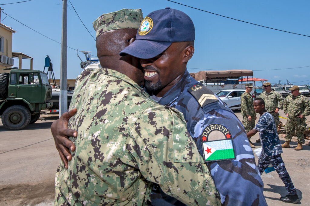
Master Chief Culinary Specialist Dexter Baird, senior enlisted leader assigned to Maritime Expeditionary Security Squadron 11 (MSRON-11), Commander, Task Group 68.6, currently deployed to Camp Lemonnier, says goodbye to members of the Djiboutian navy following a six-week professional maritime orientation course, Oct. 14, 2021. The course, initiated by MSRON-11, was designed around basic line handling, man overboard, engineering, seamanship, lifesaving, and nautical terminology. U.S. NAVY / Mass Communication Specialist 2nd Class Jonathan Word
With that said, we’re always exploring opportunities to experiment with and identify potential areas of unmanned aerial and surface technology that would effectively integrate into our force.
What role, if any, does NECC have in training foreign forces in operation of patrol boats, EOD operations and other expertise?
DIGUARDO: One of SECNAV’s enduring priorities is for us to strengthen strategic partnerships, and we’re certainly doing that.
Although the Navy divested from the Maritime Civil Affairs and Security Training Command in the early part of the last decade, and even without a specific command coordinating those efforts within NECC, our men and women continue to build partner capacity through subject matter expertise exchanges and exercises with partner nation forces around the world.
These exchanges are effective, and the relationships and partnerships that result are truly authentic. There’s a photo from late last year where we had Maritime
Expeditionary Security Squadron 11 conducting a six-week professional maritime orientation course to the Djiboutian navy, and the photo shows one of their guys hugging our master chief at the end of it. There was gratitude and joy, but more importantly, a relationship.
That photo is validation of the importance of those types of exchanges. Not only that, but now there are 15 more Djiboutian sailors with a better level of technical aptitude in an extremely critical part of the world.
And our EOD take advantage of some of those same training and interoperability opportunities to continue our partnership initiatives and the long-term benefits that come from doing them.
What aspect of NECC do people find the most surprising?
DIGUARDO: NECC’s relevancy to current fight. It is not all about carriers, submarines and airplanes. Those are essential components of American naval power, but for NECC, our people are our weapons system. Much of what they do is in support of those larger platforms, but NECF do so through operations forward, in austere environments, while integrated with the joint force, allies and partners, or in concert with our Marine and Coast Guard teammates.
The fleet needs our Navy Expeditionary Combat Forces to close the last tactical mile so those vital platforms never run out of fuel, ammunition or other needed supplies. They need us to clear, secure, build and protect across the spectrum of operations.
We’re already doing that, but what might come as a surprise is how widespread that support is. In 2021
alone, we had more than 5,300 NECF Sailors deployed forward to 55 countries, supporting 64 requirements generated by six geographic and two functional combatant commands. That is enabling DMO lethality.
Our forces clear, secure, build and protect for the fleet and joint force. NECC is uniquely qualified to deliver at the time and point of need, often exclusive capabilities, to support integrated American naval power.
Q&A: Vice Adm. William J. Galinis, Commander, Naval Sea Systems Command
Vice Adm. Bill Galinis, center, tours a naval facility. U.S. NAVAL SEA SYSTEMS COMMAND
Vice Adm. Bill Galinis, commander, Naval Sea Systems Command, responded to questions about the Naval Sustainment System – Shipyard from Senior Editor Richard R. Burgess.
What is the Naval Sustainment System – Shipyard?
GALINIS: Naval Sustainment System – Shipyard (NSS-SY) is a Navy corporate initiative focused on meeting our on-time ship and submarine delivery commitments at all our naval shipyards. This Navy-wide approach is designed to address all functional areas affecting execution performance in our public shipyards to include planning, material procurement, engineering, waterfront execution, facilities, information technology and fleet partnership. For years, we have struggled to deliver submarines and aircraft carriers back to the fleet on-time from scheduled maintenance periods. Over the last decade, we’ve worked to increase productivity by growing the size of our workforce, improving our training processes to accelerate learning and get our newest hires to the waterfront as quickly as possible. In working to improve the on-time performance of the shipyards we realized that we needed to rethink how we approached both the way we plan and execute the work.
At the heart of NSS-SY is the “get real, get better” approach. The direction provided in the CNO’s [Chief of Naval Operations’] Charge of Command to self-assess, self-correct and learn is clear. For us, that means that we need to look at our processes and procedures, understand where there are barriers that hinder or slow production work and then permanently remove them. To do this, we follow a stair-step process that empowers everyone from the deckplate or shop floor all the way up to me to fix issues or elevate them up the chain of command until it reaches the right level where the issue can be addressed. We call this the “fix or elevate” process, and it allows us to identify issues that prevent our production workforce from getting their job complete on time. The issue could be that our mechanics do not have the right tools, drawings or material on hand and we work with all of the Navy’s stakeholders — across the shipyard enterprise, NAVSEA, other Navy system commands, the fleet or Navy leadership as required — to ensure that our people have what they need, when they need it, so they can do their job.
Two additional important elements of the NSS-SY effort are the requirement to standardize practices across our naval shipyard enterprise. This includes starting with how we train our workforce, our business practices, material procurement efforts and work execution processes. There is tremendous opportunity in this area.
During this era of strategic competition, and when you consider the average cost of about $1 million per day to keep a submarine in a shipyard, every day matters when it comes to our availabilities. Every day of maintenance delay costs the Navy steaming days, training days, and forces other ships and crews to stay out longer. With NSS-SY, we are working to ensure that we maximize our skilled workforce so we can continue to deter aggression and win in a fight.
How and when did NSS-SY originate?
GALINIS: NSS-SY has its roots in Naval Sustainment System – Aviation when Naval Air Systems Command [NAVAIR] took on the challenge to have 80% of our F/A-18E/F Super Hornets and EA-18G Growlers mission capable. NAVAIR not only met but exceeded its requirement, and we in NAVSEA saw the goodness inherent in the NSS process and started applying it to our naval shipyards.
The level of complexity in maintaining a nuclear submarine or aircraft carrier is enormous, so we had to not just scale up what NSS-Aviation did, but really elevate the whole process to a new level. We worked diligently within NAVSEA headquarters and the naval shipyard enterprise to start the process. Initially leveraging the Navy’s Performance to Plan initiative focusing on data and data analytics to identify key deficiency areas, we learned pretty quickly that we needed to take a much more holistic approach that brought senior leaders from multiple NAVSEA equities, other Navy Systems Commands, the fleet and Navy leadership.
This process led to the establishment of the NAVSEA Transformation Office led by NAVSEA’s executive director Giao Phan and is comprised of nine pillars, each lead by a one- or two-star admiral:
• Engineering: Rear Adm. Jason Lloyd (NAVSEA 05) • Planning: Rear Adm. Jim Downey (PEO CVN) and Rear Adm. Dave Goggins (PEO SSN) • Materials: Rear Adm. Ken Epps (NAVSUP WSS) • Inside Shops: Rear Adm. Scott Brown (NAVSEA 04) • Waterfront Production: Rear Adm. Scott Brown (NAVSEA 04) • Fleet Operations: Rear Adm. William Green (USFFC N43) • Shipyard Resourcing: Rear Adm. Scott Brown (NAVSEA 04) • Infrastructure: Rear Adm. Troy McClelland (PEO SIOP) • Information Technology: Rear Adm. Huan Nguyen (NAVSEA 03).
Additionally, within each shipyard, aligned to the waterfront production pillar, we have established execution teams lead by “champions.” Our champions are senior, experienced shipyard personnel recognized as experts by leadership and their peers in the areas they are leading. This is really where the proverbial “rubber meets the road” and this team is driving the change we need inside our shipyards.
This team is working to ensure that we are aligned and working together, from NAVSEA headquarters to the shipyard waterfront to provide our skilled mechanics and trades with the material, training, equipment, technology and facilities required to execute their mission on time. These leaders are responsible for solving issues at their level and elevating issues as needed to improve the output of the naval shipyards.
Why the need for a change?
GALINIS: As CNO [Adm. Mike Gilday] wrote in his NAVPLAN, “There is no time to waste — our actions in this decade will set the maritime balance of power for the rest of the century.”
We are in an era of strategic competition with China and Russia. Both those countries are making significant investments in their navies and air forces to try and disrupt global dynamics and stability for their own economic benefit. Our Navy serves as the stabilizing force across the globe, and that is true because we are forward deployed and have the greatest Sailors and ships of any nation. Fleet readiness is top priority and foundational to executing our sea control and power projection missions. The work to provide our Navy and our country with materially ready submarines and aircraft carriers starts in our four public shipyards. Our naval shipyards are critical in ensuring that our submarines and aircraft carriers are materially ready to fight and win. NSS-SY is working to ensure that these front-line assets are delivered on time, every time so the fleet can meet its mission to preserve peace and win wars.
How is it an improvement on the way ship sustainment was done in the past?
GALINIS: The primary difference between NSS-SY and other efforts to improve naval shipyards’ performance is the whole-Navy approach we’re taking. No longer are we putting the onus on the individual shipyards to figure out how to improve. Instead, we are using metrics, data analytics, and workforce input to drive the procedural changes and business rule updates needed to ensure that we provide the production and engineering workforce with the full scope of what they need to be successful and make every day of a maintenance availability matter.
As I said earlier, we’re taking a holistic approach to how the naval shipyards are supported from across the entire Navy. Under Fleet Maintenance Officers Rear Adm. Greene and Capt. [Daniel] Ettlich, both former naval shipyard commanders, we are working with the fleets to improve our productive capacity within each shipyard by adjusting targets for our wage grade, or trade, personnel while also building a path to become a “master mechanic,” essentially providing a career in the trades with the appropriate level of training and compensation.
No availability can be completed on time if the planning and engineering isn’t done right, so Rear Admirals Downy and Goggins are working to improve our planning efforts by refocusing of planning milestone adherence and the quality and completeness of the planning products delivered to the shipyards. Rear Adm. Jason Lloyd has developed a team to address non-value-added requirements and “engineer work out” of availabilities to improve our on-time performance. Where the on-time procurement and delivery of material has proven to be one of our bigger challenges, and tied to our planning and engineering efforts, Rear Adm. Epps has implemented Material Planning Conferences tied to our availability planning efforts as well as rebuilding our rotatable pool processes.
On the infrastructure front, under Rear Adm. Nguyen, we’re working to improve our IT infrastructure to improve connectivity and information sharing while also working to upgrade computers at the four shipyards to improve productively and reduce unproductive time.
Adm. McClellan is executing the required physical infrastructure upgrades needed to execute maintenance in as efficient manner possible, with active projects in progress at Portsmouth and Norfolk and soon in Pearl Harbor and Puget Sound.
It all comes together on the waterfront and in our shops, and that is where Rear Adm. Brown is focused on a really, “back to basics” effort. As mentioned earlier, there are strong teams within each shipyard, led by our champions, working to implement the required change in this pillar. The focus here is to essentially rebuild our management and execution processes for executing complex ship maintenance and modernization efforts. Additionally, he has a strong effort in place to improve production shop performance, ensuring the production shop workforce has what they need to execute their mission.
USS Pasadena (SSN 752) returned to the fleet Oct. 31 following successful completion of its Drydocking Selected Restricted Availability at Norfolk Naval Shipyard. U.S. NAVY / Aldo Anderson
What are some of the lessons learned from the first four submarine pilot projects? Did they emerge from the shipyard on time?
GALINIS: Each shipyard has executed a number of initiatives we call sprints that are designed to quickly test ideas. During the first phase of NSS-SY, we focused on the waterfront production system and piloted OCC [Operations Control Center] and Start of Shift initiatives across four submarine CNO availabilities — USS Mississippi (SSN 782), USS Louisiana (SSBN 743), USS Virginia (SSN 774) and USS Pasadena (SSN 752).
Not every sprint resulted in positive outcomes. One example was our testing a new way to record work time for the production workforce. We thought we could remove some work hours at the supervisory level but, when we evaluated the pilot, we did not see the return on investment so we ended the pilot pretty quickly so we could put our efforts elsewhere. Although we don’t like to see our effort not pan out, it’s better that we fail fast so we spend more time in areas that may result in real time or energy savings.
A consistent theme in what we learned with the early efforts was a need to scale successful pilots quickly — the crew boards for example. Our approach here will be to implement pilot efforts where we see the need for improvement, quickly assess the impact of these pilots, and, if they work, scale them quickly across the four naval shipyards.
Our near-term efforts are really focused on the waterfront pillar to rebuild and reinforce the importance of our project management fundamentals. Improving our waterfront execution efforts, combined with near-term wins in material, engineering and IT, is where I believe we will have the most impact on avails in progress.
Looking a little further out, improving our planning efforts, getting this planning done on time with the requisite level of quality, combined with improved on time material procurement and delivery will be impactful. This will also improve our ability to manage the production work during a submarine or aircraft carrier availability.
Have you started any follow-on (post-pilot) availabilities using NSS-SY? Have you expanded beyond applying it to submarines?
GALINIS: Yes, we have. For example, we’ve established operational control centers that have been fully implemented for all CNO availabilities in progress and even into some of our shops.
The operational control centers are integral to our fix or elevate approach as issues identified at the waterfront or shop floor are sent there for evaluation and are either fixed or moved up the chain of command. It allows the project teams and trades a single place to send issues they cannot address themselves and serves as a way to bring subject matter experts together into a single space to investigate and address productivity barriers. This effort has driven down work stoppages in terms of numbers and durations on the waterfront and shown some improvement in getting decisions to the waterfront faster.
We’ve also continued to mature the use of crew boards across our availabilities, incorporating feedback from the waterfront. These crew boards lay out what specific work teams should accomplish that day. In establishing this daily goal, our tradespeople can better understand what they need to do and make every day matter. It also helps to track the status of ongoing work and help identify barriers to completion.
Additionally, the work being done within the waterfront pillar to improve and strengthen work execution principles, what we refer to as “project management fundamentals,” or PMF, has been very important. PMF is the tactical process used by our project teams to manage work execution during ship maintenance availability. The team is taking a back-to-basics approach to strengthen the training and understanding of these fundamentals, reinstill consistency of implementation and adherence, measuring throughput and incorporating commercial best practices where appropriate. This is one of our top focus areas to improve availability execution in the near term.
What metrics do you use to assess the success of availabilities under NSS-SY?
GALINIS: Ultimately, the only metric that counts is the number of days of maintenance delays. Our goal is to deliver all availabilities on time by 2023.
We have identified a number of metrics that we know will lead to a decrease in the number of days of maintenance delays. For example, we are looking at on-time task completion, how much production work is accomplished each day as compared to a daily schedule, and how much we are reducing unplanned work, or work that is not identified prior to the start of the availability. We are constantly reassessing how we measure ourselves to ensure we stay focused on the right measurements and tasks.
We also have tangential information about our workforce’s buy-in to the program. When we first started rolling out crew boards, they did not go to every shop on every availability. Instead, we tested the concept with a couple shops on a couple availabilities. One day, a supervisor walked past a crew board, saw the goodness and value in sharing that information, and on his own built his crew their own crew board. When you have that type of buy in to a concept, you know you’re on to something good.
What new technology, if any, has been introduced as part of NSS-SY?
GALINIS: While NSS-SY is principally focused on improving our business and production practices, and I discussed the importance of standardizing of our practices, equally important is our ability to innovate and improve our processes as well as bring in new technology. We have consistently encouraged and challenged our shipyard to look for improvement opportunities.
A good example of driving innovation into our work practices is the current friendly competition between Portsmouth and Pearl Harbor Naval Shipyards on Virginia-class work practices to drive time and cost out of these availabilities.
On the technology front, we stood up an Engineering Intervention Board to more efficiently and quickly evaluate new technologies as part of its effort to remove schedule and cost from availabilities. And many of these new ideas come from the waterfront.
Examples of technologies the EIB is currently evaluating include an automated condenser cleaning system that cleans condenser tubes while saving substantial time. We are also looking into an autonomous grit-blasting system that also reduces the workforce requirements. Same for a phased array ultrasonic non-destructive testing technique and laser ablation that removes rust and other materials with a laser beam and not a wire brush or wire wheel.
What are the cost advantages, if any, demonstrated by the NSS-SY projects?
GALINIS: NSS-SY is focused on improving business practices within the shipyards and maximizing the productive time of our artisan and engineering workforce. It’s about on-time work completion that results in on-time deliveries and therefore on-cost deliveries as well. From a shipyard perspective, providing our waterfront mechanics/trades the right material at the right time, the right tools, technical information, etc., will allow them to be more efficient. The more effective we make our skilled tradespeople, the quicker they can complete a job and then move to the next one, which reduces the number of work hours and days in an availability, and the quicker we can buy back idle time for the ships and their crews.
That said, there is a cost component to delivering ships on time. For every day a submarine is delayed in an availability, the Navy expends about $1 million. That includes all the operational costs for the boat. For aircraft carriers, that figure doubles to $2 million. When the ship and its crew is in the shipyard, the Navy is not getting productive capacity from its investment.
Similarly, there is a readiness deficit that we run when we do not deliver on time. For the delayed ship and its crew, that’s less time working together as a team, at sea, where they need to be to gain true warfighting proficiency. It also causes us to run deployed crews and their ships longer and harder than we want and that has an impact on our people and warships.
Ultimately, NSS-SY is about delivering ships on time, every time but ensuring our workforce has what they need, when they need it, to get the job done.
What feedback are you getting from the shipyard workers on NSS-SY?
GALINIS: The feedback has been positive. As with every new concept it takes a while for people to really understand what we’re doing and why we’re doing it. We are really starting to see the momentum build for the NSS-SY efforts. We need to drive the credibility and ownership of this effort to the waterfront. The credibility piece will be built by demonstrating how these initiatives make the job easier for our tradespeople by ensuring they have the right material when they need, they have the right work sequence, correct technical drawings and the ownership element. We are seeing now where the shipyards are using the NSS-SY efforts to drive improvements in the shipyards.
Frankly, our shipyard personnel were a little guarded about NSS-SY to start. They have seen other attempts to improve productivity that have had limited success. Additionally, there was some who thought NSS-SY was going to add an already high workload. While there is some investment/work upfront required, the bottom line here is that the improvements we are making need to make it easier for our naval shipyard waterfront teams to meet their commitments. NSS-SY is about making these teams successful. The focus here is to remove barriers and provide the resources required to enable them to do their job safely and on-time.
Our naval shipyards are national assets, and our people are the heart and soul of this enterprise. We have a leadership team aligned on the imperative to improve — to get real and get better. The shipyard team is committed to meeting our commitments to the fleet in terms of on time delivery. Through the NSS-SY effort, we have developed a process to improve our execution performance, measure our improvements and correct where required and hold ourselves accountable for sustaining this performance across our naval shipyards.
How does NSS-SY relate to the Shipyard Infrastructure Optimization Program?
GALINIS: NSS-SY and SIOP share the same goal of setting our public shipyards up for long-term success with success being measured in the on-time delivery of submarines and aircraft carriers out of maintenance availabilities.
SIOP is focused on recapitalizing the physical infrastructure — upgrading the dry docks and the shipyard infrastructure to include our shop facilities, and then the industrial plant equipment, all required to execute maintenance on new classes of submarines and aircraft carriers.
NSS-SY, on the other hand, is about updating our business practices, work execution processes and procedures to support the on-time execution of ship availabilities and ensure our mechanics and engineers have the tools and material they need to safely execute their work on time and with minimal or no delays.
Separately, NSS-SY and SIOP will result in substantial positive changes within the naval shipyards. When you combine NSS-SY and SIOP together, you have the truly fundamental and unprecedented investment that our shipyards require to execute maintenance on time, every time for generations to come.
Do you foresee expansion of NSS-SY concepts to private shipyards for Navy ship availabilities?
GALINIS: Yes, I do, and in fact we are sharing best practices and lessons learned from our NSS-SY efforts with our counterparts in the private sector. A component of NSS-SY is the Navy adopting industry best practices in order to become more efficient. That said, it will only benefit the Navy to share our best practices with our ship maintainers and builders.
Q&A: Vice Adm. Roy Kitchener, Commander, Naval Surface Forces, Commander, Naval Surface Force, U.S. Pacific Fleet
Vice Adm. Roy Kitchener, Commander, Naval Surface Force, U.S. Pacific Fleet, speaks with Hospitalman Shakeelah Jordan aboard the Arleigh Burke-class guided missile-destroyer USS Winston S. Churchill (DDG 81) during a ship visit. Kitchener visited Hampton Roads commands and ships in June 2021 and hosted a commander’s call with waterfront leadership. U.S. NAVY / Mass Communication Specialist 2nd Class Jacob Milham
Vice Adm. Roy Kitchener assumed command of Naval Surface Forces and Naval Surface Force, U.S. Pacific Fleet in August 2020, and as a type commander he has guided the forces as he continues to man, train and equip the forces for duty in the fleet and service to the U.S. combatant commands. A native of Trumbull, Connecticut, and a 1984 graduate of Unity College with a Bachelor of Arts in political science, he attended the Navy Officer Candidate School in Newport, Rhode Island, and received his commission in 1985. He also attended the Naval Post Graduate School where he specialized in Western Hemisphere studies and earned a Master of Arts in national security affairs.
As a surface warfare officer, he deployed around the world and commanded destroyers, cruisers and an expeditionary strike group. At sea he served as a division officer aboard USS Dewey (DDG 45); operations and training officer for Special Boat Unit 26, Republic of Panama; combat systems and weapons officer aboard USS San Jacinto (CG 56); executive officer aboard USS Cowpens (CG 63); and operations officer and chief of staff for Commander, Carrier Strike Group 11. He commanded USS John Paul Jones (DDG 53) and USS Higgins (DDG 76) during the Navy’s Sea Swap Initiative, and also commanded USS Princeton (CG59) and Expeditionary Strike Group 2.
Ashore, Kitchener served as the Surface Warfare Directorate’s Naval Surface Fire Support program officer on the staff of the Chief of Naval Operations; combat systems instructor at Surface Warfare Officers School; ballistic missile defense operations chief at the Cheyenne Mountain directorate at Commander, U.S. Northern Command; and vice commander of Naval Mine and Anti-Submarine Warfare Command. He served as the chief of staff at numerous commands, to include commander, U.S. 3rd Fleet; commander, Naval Surface Forces; commander, Naval Striking and Support Forces North Atlantic Treaty Organization (NATO); and U.S. deputy military representative to the NATO Military Committee. Most recently, he was commander, Naval Surface Force, U.S. Atlantic Fleet.
Kitchener responded to questions about the surface Navy fleet from Senior Editor Richard R. Burgess.
The surface Navy is better armed today than it was decades ago, when it was primarily an anti-air and antisubmarine escort force. How has that improvement affected the morale and professionalism of surface warriors?
KITCHENER: No doubt, we have seen tremendous improvements in our network and sensors that give our ever-improving weapons better speed, range and precision. However, I would propose it is our training investments that have had the most impact on the professionalism of the force. The surface force develops leaders, warriors, mariners and managers, and each of these roles requires training, education and mentoring. A well-trained Sailor is a confident Sailor. That is why we have dedicated more than $5 billion to the Surface Training Advanced Virtual Environment for Surface Force training. Approximately 200 STAVE projects are supporting training in all areas of individual and waterfront training, including navigation and seamanship, engineering, damage control and combat systems. Furthermore, nearly 66% of all afloat billets benefit from STAVE. This training and the human factor programs that we have in place directly contribute to improving our Sailors’ professionalism and morale.
The surface Navy has had few combat actions at sea since World War II. How confident are you that today’s surface warriors are trained and conditioned to maneuver and fight as well as execute damage control should they fight a peer competitor?
KITCHENER: We are highly confident in the training and professionalism of our surface force. As previously stated, we have dedicated a significant amount of resources to ensure our force is trained and ready to meet today’s operational challenges. In addition to investing in STAVE, we are also building the physical and digital infrastructure to support this vast amount of training we are providing to our force.
Most notably, the Mayport [Florida] and Sasebo [Japan] Shiphandling Trainers opened for business in 2021, bringing the number of learning sites to 10 overall and ensuring a site in nearly every fleet concentration area. The Mariner Skills Training Centers in San Diego and Norfolk began hosting a two-phase Officer of the Deck [OOD] course, which shifted from a JOOD [Junior OOD] course to a two-phase OOD curriculum. The change freed up the Advanced Division Officer Course to expand its focus on maritime warfare. ADOC is now providing junior officers with three weeks of maritime warfare training instead of one, allowing us to lay the warfighting foundation earlier in an officer’s career.
Regarding specific warfighting training, we are installing virtual operator trainers, or VOTs, in all homeports to provide Sailors with training for the AV-15 sonar system and Aegis Baselines 9 and above. In Yokosuka, Pearl Harbor and San Diego, the sonar trainers are up and running and the Aegis VOTs in Yokosuka and Pascagoula are soon to follow.
Finally, we have worked with the numbered fleet commanders to retool and enhance the high end, at-sea training ships receive prior to deploying to ensure they are ready to defeat current day threats. Never before has our force possessed this quality of warfighting training systems in our homeports, and they are available to commanding officers to build their teams’ skills.
Has the seamanship of the force been improving to meet your expectations in the five years since the McCain and Fitzgerald incidents?
KITCHENER: Yes. We have made significant investments to increase the amount and depth of training that junior surface warfare officers receive before they report to their ship.
We introduced and implemented a revised SWO training and assessment continuum that employs navigation, seamanship and ship handling assessments across all career milestones.
We also implemented NSS/go/no-go assessments with four no-go criteria established for a SWO career path, which means that no one gets a pass simply due to experience. We assessed all officers at every level, from brand new ensign to major commander. Those who do not pass their proficiency tests do not assume command of ships at sea. Our standard: To be a professional mariner is more rigorous now than ever.
For our younger officers, the two-phased OOD course provides advanced practical instruction in navigation, seamanship, and ship handling in high-end simulators, emphasizing rules of the road, high-density shipping, in-extremis maneuvering and watch team management.
How are simulators making better surface warriors?
KITCHENER: With the number and complexity of systems and platforms planned to join the fleet in the next decade, the requirement for clear and innovative operational concepts is critical. Simulators provide our surface warriors with a controlled environment to develop and refine their mariner skills. By perfecting these skills in a teachable setting, Sailors can enter the fleet with the most advanced knowledge.
Sonar Technician (Surface) 1st Class Kendall Cochran, assigned to the Freedom-variant littoral combat ship (PCU) Minneapolis-Saint Paul (LCS 21), trains using computer-generated simulations during Surface Training Advanced Virtual Environment scenarios at Surface Combat Systems Training Command Detachment Southeast, LCS Training Facility, Nov. 9, 2021. U.S. NAVY / Chief Mass Communication Specialist David Holmes
What are the chief challenges to improving force readiness?
KITCHENER: The completion of depot level maintenance on time continues to be a significant challenge. We have invested in analytics to help us improve in this area.
As I said at SNA [Surface Navy Association convention] earlier this year, we have seen improvements in two key metrics that we are using to gauge our progress: days of maintenance delay and on-time completion rates. Since 2019, we have reduced our days of maintenance delay by 41%. Our on-time completion is steadily increasing, from 34% in fiscal year 2019 to a projected 59% for all 2021 avails, including those ongoing that began in fiscal year 2021. We still have more to do, but it has been satisfying to see that the process is working.
Overcoming this challenge is even more important as we deliver modernization upgrades to the fleet, capability that is essential to maintaining our warfighting advantage. The SPY-6 radar and AN/SLQ-32(V)7 electronic warfare suite are a couple of examples of the extensive modernization programs that we will introduce to the fleet. The effective and timely execution of our maintenance and modernization packages during depot avails will be even more important to force readiness as we install this vital capability.
You have spoken about reimagining fleet introduction. What do you mean by that?
KITCHENER: Historically, NAVSEA’s [Naval Sea Systems Command’s] fleet introduction team provided oversight on the acquisition process and integrated the various program offices in the delivery of a new ship. Independently, the type commander’s fleet introduction team would be responsible for actually integrating the ship into the fleet. We feel that a good look at this process will provide us a better process. Reimagining means thinking differently about this process so that the type commander is more engaged in the acquisition process overall, and that the program offices can deliver new ships and capabilities that integrate with the fleet more effectively and efficiently. We anticipate that this review should have significant positive impact and therefore I’ve asked Rear Adm. Brendan McLane at CNSP [commander, Naval Surface Force, U.S. Pacific Fleet] to take on this task.
We are introducing at least 10 new or modernized platforms to the force in the next decade, and believe that effective fleet introduction is critical to maintaining a competitive advantage.
What is the role of Task Force LCS that stood up last spring?
KITCHENER: We stood up Task Force LCS to consolidate efforts and drive actions across the LCS [littoral combat ship] program. Experts across the Navy are working together to analyze, develop and rapidly implement improvements to LCS platform reliability, sustainability, lethality and operational employment. The task force, led by Rear Adm. Robert Nowakowski, continues to provide databased recommendations and solutions to improve the reliability and sustainability of the LCS program.
What will be the role of the unmanned surface vessel division standing up this summer? How has Surface Development Squadron One been pushing the envelope in unmanned systems?
KITCHENER: This summer, USV Division One will stand up and grow to 103 Sailors in 2022 to provide dedicated support to USV operations. The command will be led by an O5 SWO commander and will report to SURFDEVRON [Surface Development Squadron] One and operate out of Port Hueneme, California. USVDIV 1 will be focused exclusively on USV experimentation and fleet advocacy with our program offices. The division will be a cornerstone in building the foundational knowledge required for Sailors to operate and maintain the USV fleet and spearhead the development of the processes required for USV operations and sustainment.
With the Zumwalt class to be armed for hypersonic weapons, do you expect them to deploy before their conversion? When do you expect the first conversion to start and what is the planned IOC year for them with conventional prompt strike?
KITCHENER: The Navy’s Conventional Prompt Strike Program is developing a non-nuclear hypersonic weapons system that will enable precise and timely strike capability in contested environments. Fielding hypersonic weapons is a top technical research and engineering priority and the Navy continues to accelerate the development of hypersonic capabilities. The Navy is on track to field the CPS on Zumwalt-class destroyers in fiscal 2025.
In support of the Zumwalt class, being the first platform to deliver CPS capability, the Navy commenced engineering design planning that will allow for integration of CPS during a planned fiscal 2024 dry-docking selected restricted availability. The ship’s relatively large volume and timing of her already scheduled dry docking availability are key enablers to rapidly field CPS capability in USS Zumwalt.
Looking on the success of the DDG 51 class, what capabilities do you want to see in DDG(X)?
KITCHENER: The DDG(X) class will capitalize on the success of the DDG 51 class by improving an already exceptional craft. DDG(X) will utilize a variant of the DDG-51 FLT III combat system integrated into a new hull form with flexibility for upgrades, an efficient integrated power system and greater endurance, reducing the fleet logistics burden.
Dahlgren Focuses Energy Weapons on Target
Arleigh Burke-class guided-missile destroyer USS Stockdale (DDG 106) Sailors prepare to conduct a replenishment-at-sea with Nimitz-class aircraft carrier USS Carl Vinson (CVN 70), July 12, 2021. Stockdale’s Optical Dazzling Interdictor (ODIN) laser system is seen just below the bridge. U.S. NAVY / Mass Communication Specialist Seaman Elisha Smith
DAHLGREN, Va. — The U.S. Navy has been researching and perfecting directed energy weapons to include railguns, high-powered microwaves and lasers, along with hypervelocity projectiles — to make futuristic weapons a reality on ships today.
The Naval Surface Warfare Center Dahlgren Division in Dahlgren, Virginia, has been leading the way in creating capabilities to give warfighters a high-tech advantage at sea, to include directed energy weapons.
“We take great pride in being a hands-on research, development, test and evaluation institution, where we possess and practice the organic technical knowledge for the Department of the Navy with respect to surface warfare,” said Dale Sisson, NSWC Dahlgren Division’s technical director. “That ends up being a fairly broad ranging mission, for sure. Having the opportunity to design, develop, test and integrate warfighting systems through the confluence of a physical range infrastructure, and a digital architecture such as our digital proving ground, is fundamentally who we are.
“We’re also in the threat engineering business, which means we understand those threats well, and that knowledge translates back into understanding how to develop the weapons to counter that on a defensive standpoint, as well as create the offensive advantage that puts us ahead of the game,” said Sisson.
While the Navy’s railgun efforts are currently on hold, laser systems are installed or in the process of being integrated into ship combat systems today. In fact, much of Dahlgren’s work on railguns is being leveraged today for new capabilities such as hypervelocity projectiles.
Today, lasers are a reality in the fleet. A prototype Optical Dazzling Interdictor, Navy, or ODIN system, designed and built by Dahlgren, is being evaluated aboard the Arleigh Burke-class guided missile destroyers USS Dewey (DDG 105), and other Burke-class ships. The Lockheed Martin High-Energy Laser with Integrated Optical-dazzler and Surveillance system is being tested aboard another Burke-class ship, USS Preble (DDG 88). The Solid-State Laser Technology Maturation (SSL-TM) program is developing an integrated Laser Weapons System Demonstrator, built by Northrop Grumman, which is installed and being tested aboard landing ship dock USS Portland (LPD 21).
All of them can thank Dahlgren for vital concept development, design and testing. Dahlgren’s Laser Lethality Laboratory and Laser Firing Range have provided knowledge, expertise and experience to mature the technologies and integrate the capabilities into the combat systems on the Navy’s warships.
“Our laser firing range allows us to fire across Upper Machodoc Creek so we can examine how the maritime boundary layer between the water and the atmosphere affects laser performance. We have a two-story building within our explosive experimental area we use as a backstop for laser beams,” Sisson said. “We can shoot up to about four kilometers, depending on where we position lasers on the range from the backstop.”
Dr. Chris Lloyd, distinguished scientist for laser weapon system lethality, leads the Navy’s laser lethality efforts.
“NSWCDD has extensive experience in integration of Navy laser weapon systems, from subcomponents up to full systems. The Navy laser lethality team supports development, assessment and deployment of laser weapons and conducts rigorous testing, modeling and simulation to drive requirements for advanced laser weapon system development for the Navy. Lethality is more than simply damaging materials, but understanding how threats are going to respond. We have to understand threat response, based on the damage we inflict, and apply that data, along with weapon system parameters and propagation information to tell the complete weapon effectiveness story,” he said.
“Our industry partners team closely with the government directed energy workforce to integrate and test laser weapon systems at Dahlgren test ranges as well as other DoD test locations in the country,” said Lloyd. “If they have a system that’s ready to be tested in preparation for deployment, we can use actual system performance test data in our lethality and effectiveness analyses to validate models and assess overall lethality.”
1001 Amphibious transport dock ship USS Portland (LPD 27) successfully disabled an unmanned aerial vehicle with a solid-state laser, Technology Maturation Laser Weapon System Demonstrator (LWSD) MK 2 MOD 0 in May 2020 in this still image from U.S. Navy video from Pacific Fleet Public Affairs. U.S. NAVY
Working Together
Lloyd said the Dahlgren team has been part of technical area working groups that have been together for the better part of 20 years, and, as a result of that, have become very proficient at working together and sharing data.
“We collaborate closely with the Army, Air Force, Missile Defense Agency and the Joint Directed Energy Transition Office,” he said. “We also work with the FFRDCs [Federally Funded Research and Development Centers] and academia to advance key S and T [science and technology] areas.”
Dahlgren’s lethality lab has several key features, including a repurposed World War II tunnel for longer range propagation studies. It’s environmentally controlled, and can introduce moisture and aerosols to see how they affect not only propagation but lethality.
“We can look at battlefield contaminants, atmospheric conditions, and understand lethality through those conditions,” said Lloyd.
“We’re in the business of putting holes in targets and damaging components. That’s the ‘target vulnerability’ piece of it,” he said. “But we’re interested in the overall weapon lethality. We have to understand the weapon system performance specifications, as well as the atmospheric conditions and the impact on overall effectiveness. We work very closely with the atmospheric community to grasp those principles and pull them into the modeling. We also collect vulnerability data on different materials all the way up to subsystem components and full systems.”
Another aspect of Dahlgren’s laser lethality efforts involves the modeling and simulation analysis team. “Fundamental properties for the materials we test against are fed into those models, along with all the basic parameters like conductivity,” said Lloyd. “It all has to be well understood.”
Sisson said the science and technology is important, but Dahlgren’s staff knows how to put that knowledge into practical systems.
“We have the technical knowledge to build a system. But that’s not enough. We have that true subject matter expertise that knows how to design, develop, deliver and field systems. When we’re working on a tactical laser system, our engineers also understand systems integration and what it takes to go acquire things. We have to be able to install and operate that system on a ship reliably and effectively,” Sisson said. “We need a system to target the beam and conduct battle damage assessment, and it has to integrate with the ship’s combat management system. We have to be able to make it fit and work on a ship in a challenging maritime environment.”
Not Just A Laser
“Dahlgren has been instrumental in the continued technology maturation for high energy lasers and the success of LWSD,” said Donna Howland, acting general manager of Northrop Grumman’s Directed Energy operating unit. “We learned from their expertise on how to operationalize high energy lasers.”
“It’s not just a laser. We want to integrate the laser — as both a sensor and weapon — as a full participant in the combat system,” said Capt. Casey Plew, NSWC Dahlgren Division’s commanding officer. “We’re building a weapon that includes the mount, power, thermal management, command and control, tracking and doctrine, all done in coordination with government, industry and academia partners.
“Lasers are a great piece of the mission we perform, but they are only one part of the complex puzzle. And the awesome women and men of NSWC Dahlgren Division have been helping to solve our surface navy warfighting puzzles — for almost 104 years. It is in our DNA. It is what we do,” said Plew.
AIs on the Prize: Competitions Foster Artificial Intelligence Applications for Naval Use
Advanced Naval Technologies Exercise 2021 provided government, industry and academia participants a collaborative, low-risk environment that leverages the Naval Research and Development Establishment’s unique laboratories and ranges, while practicing operators and planners simultaneously explore advanced tactics and assess the operational relevance of emerging technologies. U.S. NAVY / Joe Bullinger
Recent initiatives by the Department of Defense to foster rapid innovation and modernization have involved conducting prize competitions among existing and would-be defense contractors to develop technology for military use. The competitions enable small businesses to put forth and demonstrate their ideas in realistic scenarios and can, in time, lead to production contracts.
Artificial intelligence and machine learning is one area receiving intensive attention from the Defense Department because of the increasing challenges of managing overwhelming amounts of data and making decisions in a timely manner. The challenge is made even more acute because of the present sophisticated peer competition with China and Russia. The current politico-military situations in Ukraine, the Taiwan Strait and the South China Sea are scenarios in which AI/ML potentially can help decisionmakers. AI can have applications at the national level all the way down to the tactical level. The technology can help not only with situational awareness but also with predictions — indications and warning.
In a recent prize competition sponsored by the Department of Defense, a small company named BigBear.ai, headquartered in Columbia, Maryland, won the prize. The competition between 12 teams was a Project Overmatch AI Advanced Naval Technology Exercise, or ANTX.
Brian Frutchey, chief technology officer for BigBear.ai, said the company adapted for the Navy a program developed for the U.S Army, which was “dealing with hybrid warfare, the gray zone conflict out in Eastern Europe and wanting to find tools that could automate the sense-making of all of the different data that they need to look at for the hybrid warfare environment.”
It was not just “counting the planes and tanks and soldiers anymore,” Frutchey said. “They have to look at the economies, political relationships, migration of people, cyber activity, all these new domains that the strategic analyst needs to be cognizant of and needs to model into their anticipatory intelligence.”
BigBear.ai built the Virtual Anticipation Network (VANE) — the weathervane — to point to where the winds of war were blowing. Now the dominant product at Big Bear.ai, VANE, funded by the deputy assistant secretary of defense for Special Operations in Low Intensity Conflicts, was used by the company to win the $75,000 prize in the ANTX. BigBear.ai was one of 12 companies selected to participate in the competition, which was conducted during the last half of 2021.
Frutchey said in the ANTX the VANE was looking for telemetry for maritime vessels and aircraft, as well as weather, the information environment, among other domains “that we brought together so that we could inform when these things are happening with airplanes flying through the Taiwanese air defense zone [ADIZ],” including events leading up to and during the events of interest, such as Chinese aircraft entry into the ADIZ; rerouting of air traffic; even press releases. As the observation of the indicators is automated, human analysts are able to handle more data “and with a significant amount of agility be able to pivot to new situations faster than they could before.”
He says what sets BigBear.ai apart “is that we have built machine learning that expects data to not be the whole story. I think that’s key because especially for our defense and intelligence partners, you don’t always have control of the data that you’re trying to analyze. There’s always this uncertainty in the data where you have gaps and holes and inaccuracies and because of that we have to use machine learning that assumes that you’re going to be having those errors, those issues and, even further, you don’t always get to measure the stuff you want to measure.”
VANE presents its analysis on a dashboard on a monitor for analysts to observe. A “heat map or density chart” shows areas with a lot of activity in a given period.
“We also look at baseline behaviors,” Frutchey said. “The analysts get concerned when that level raises above some threshold. In the first week of October, it went to 56 [Chinese] sorties in a day at one point and they were using strategic bombers in some of those sorties. Those kinds of things are a normal low-level buzz, but I want to be alerted when the models predicting that a week from a now, a month from now, there is going to be above some threshold, or the rate of change is going to be significant. … We give them those alerts, and the user can, of course, then drill into the alert and explore the forecast data. … So, we were looking at aggressive activities in the South China Sea for the AI ANTX exercise.
“We also have scenario forecasts [that] allow you to assess courses of action,” he said. “What if Russia invades Ukraine? What will that do to the price of Bitcoin? Or what if, in the AI ANTX example, we asked the question, what if we ran a naval exercise in the Luzon Strait? What would that do to Chinese behaviors in the South China Sea? If we were to go with a carrier striker to the Luzon Strait and run a little naval exercise, what would that do to behaviors? And so, we can run those simulations and we can then show the user, here’s how the world would change a month from now if we were to run that exercise next week.”
NAVWAR Commander Rear Adm. Douglas Small presents the AI-based ANTX’s first-place prize to Big Bear.ai Chief Technology Officer Brian Frutchey, right. NAVWAR / Elisha Gamboa
VANE is scalable, Frutchey said. “Vane is built to elastically scale in the cloud as large as it needs to go. It’s actually one of the big powers on our platform is that it is completely serverless, which means it’s not like it’s a monolithic app that’s a bunch of servers chewing up resources all day long. It’s a collection of functions and, as the customers need those functions, the system is built to grab resources in the cloud, spin those up to do the work that’s needed and then turn them off when the work is done. Our systems churn through terabytes of data to build these models at global scales.”
Frutchey said the Overmatch ANTX win shows the company’s prescriptive analytics are appropriate for operational as well as strategic purposes.
“We are beginning to talk to the program offices for major command-and-control systems, [such as] the Global Command-and-Control System-Maritime,” he said.
Matching Best of Breed
AI is also being applied on a tactical level. Draper, a company known for building ballistic-missile guidance systems, entered a competition last summer conducted by the Naval Surface Warfare Center Crane Division in Crane, Indiana. The prize challenge was to determine the feasibility of taking autonomy software and implementing it on another organization’s hardware.
“I think what the government was trying to learn is how difficult is it to separate those two [software and hardware],” said Drew Mitchell, Defense Systems associate director at Draper and general manager of Draper’s Tampa, Florida, office. “That way I can match best of breed software up with best of breed hardware. Generally, those aren’t the same when the company delivers that end product to the government. And it’s also very expensive. So, they’re trying to figure out a way to reduce costs on some of these autonomous platforms.”
The prize challenge was split into three phases. In Phase 1, Draper, which had a lot of experience developing platform-agnostic software, submitted a white paper that was accepted along with those of 20 other companies. Phase 2 was a simulated exercise which involved loading autonomy algorithms into a small quadrotor unmanned aerial system and navigating it inside a building, mapping the interior and identifying objects in the building, all without the aid of GPS.
Hydronalix’s EMILY unmanned surface vessel and Adapt UAV. HYDRONALIX
Five contestants made it to Phase 3, which involved an actual demonstration of the scenario of Phase 2 using a Hydronalix quadrotor drone into which their respective software was loaded.
“It was completely autonomous, so you give the drone some sort of basic instruction, basically, fly forward and then it takes it over from there,” Mitchell said. “It senses the environment, and it does that through cameras, and it uses the same camera to do the navigation algorithm using a vision-based navigation system. It uses the same camera to collect a map of the environment or generate a map of the environment. A lot of that is very processor intensive. In a small package, like a small drone quadcopter not much bigger than a book, there’s not a whole lot of processor available on there to do all that stuff.”
Draper used vision-aided navigation algorithms it has used in its other programs.
“We used what’s called a visual inertial odometry,” Mitchell said. “It’s a lot like how the human eye and brain work in terms of referencing objects as you see them and then as you move, your brain is still calculating, oh, I saw this point and now the point is three feet from me as I move closer to it, from that point it’s now two feet from me, and from that, you can infer a lot of direction. It’s not highly accurate but it’s enough accuracy to help the IMU [inertial measuring unit] on board. It aids the IMU, so the IMU doesn’t drift off widely.
“The predominant systems today use GPS to aid that inertial unit,” Mitchell explained. “GPS gives it a position, so it knows, okay, I see that point, and then I move again, I see that point, I know where I am. But if you’re indoors, GPS doesn’t work and the big push within the Department of Defense is to do things without GPS because they know in a future conflict it’s probably going to be one of the first things our adversaries take out. Using these vision-based techniques, you’re able to get clearly decent navigation accuracy in a very small package and do this completely autonomously.
“We were able to show with very little time and resources and a very rudimentary hardware platform that the government provided us, we were able to navigate inside of a building with no GPS,” he said. “We were able to identify objects. We were able to map certain parts of an environment. Of course, it wasn’t optimal. The places that we did on our own were way better than what we’d developed through that process, but we did help the government understand that it is possible to do it.”
Draper came in second in the prize competition, with EPISCI coming in first.