

Every day, every hour, even every minute, the conflict in Ukraine is evolving. Monitoring and understanding those changes is key not only for geopolitical entities, but also corporations, humanitarian organizations and other private-sector groups.
But sifting through the abundance of data coming out of Ukraine can be overwhelming. Propaganda abounds. Videos and images may be manipulated. And traditional satellite imaging can’t capture the real-time data necessary to make informed decisions.
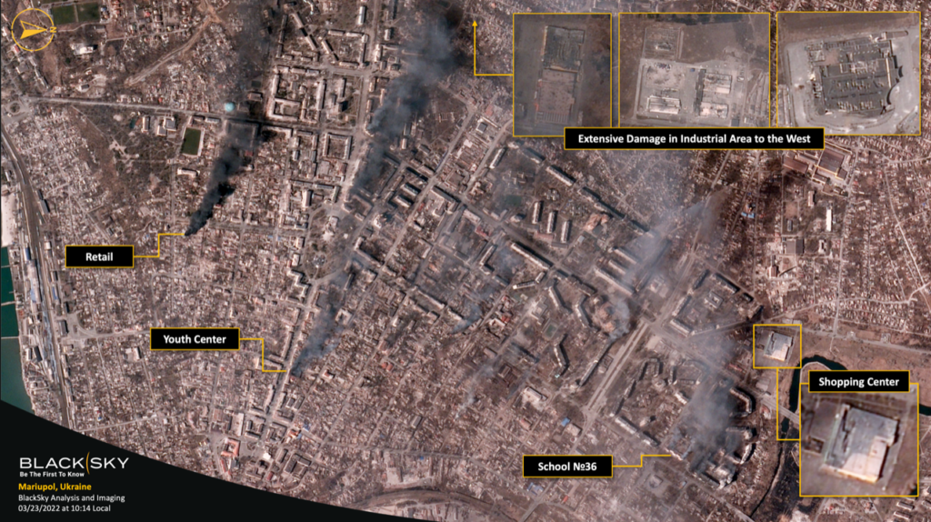
Seattle-based BlackSky (Booth 957) is solving those problems through its global monitoring services that combine artificial intelligence, cloud computing, multisensor data fusion, activity analysis and autonomous satellite tasking. Using a proprietary worldwide satellite constellation, BlackSky’s Spectra AI analytics platform provides real-time geospatial intelligence to customers in both the public and private sectors
This is quite an evolution from the core technology behind global satellite imagery, says Patrick O’Neil, BlackSky’s chief innovation officer. Traditionally, satellites are used for mapping applications, identifying landmarks like roads and buildings. But those images tend to be updated only a couple times a year, and that’s not helpful in today’s fast-moving world.
“You want to be able to take images rapidly as the situation changes,” O’Neil says. “We’re seeing the conflict in Ukraine as a kind of proving point for why real-time intelligence matters so much. Customers can’t wait for days for their overhead imagery or the analytics we supply. We’ve built our system to support that.”
The automated satellite constellation that fuels Spectra AI passes a site roughly once an hour, with the capability of tracking virtually every spot on the planet. The satellites also monitor thousands of active targets, including major airports and commercial ports around the world.
That image data is then combined with open-source information such as social media postings, news reports and press releases. Other information, such as infrared data, can show active fires and pinpoint where conflict is occurring. Spectra AI uses artificial intelligence to fuse all of this data into a single dashboard analysis that customers can pull up on a web browser, with a 90-minute delivery timeline.
“Being able to just log in and have an e-commerce-like experience where you’re buying satellite imagery and the analytics that go on top is really a pretty significant change from the historical satellite imagery patterns,” O’Neil says.
In Ukraine, BlackSky can provide images of where damage is occurring, how transportation networks are impacted and how refugee travel is flowing. It can help companies understand the macroeconomic impacts, including the availability of energy in Europe and the flow of commodities from Ukrainian port cities.
BlackSky can also track other events around the world, including natural disaster cleanups, climate-change events, wildfires, drone strikes and supply-chain operations.
“Applications like that are really quite interesting and are enabled by our unique technology,” O’Neil says. “They’re opening up use cases that previously would not have been possible.”


- 5 Ways Shipbuilding Can Be Shipshape Despite Geopolitical Instability - May 4, 2026
- Commandant Gives an Update on Marines Future - April 21, 2026
- Senior Leaders Forecast the Future of Maritime Dominance - April 21, 2026