
Sofar Launches Wayfinder Weather Routing for Dynamic Voyage Optimization


SAN FRANCISCO, Calif. — Sofar Ocean has launched Wayfinder – The Dynamic Route Optimization Platform, a real-time, data-powered application to radically improve maritime route efficiency and reduce fuel emissions, the company said in a release.
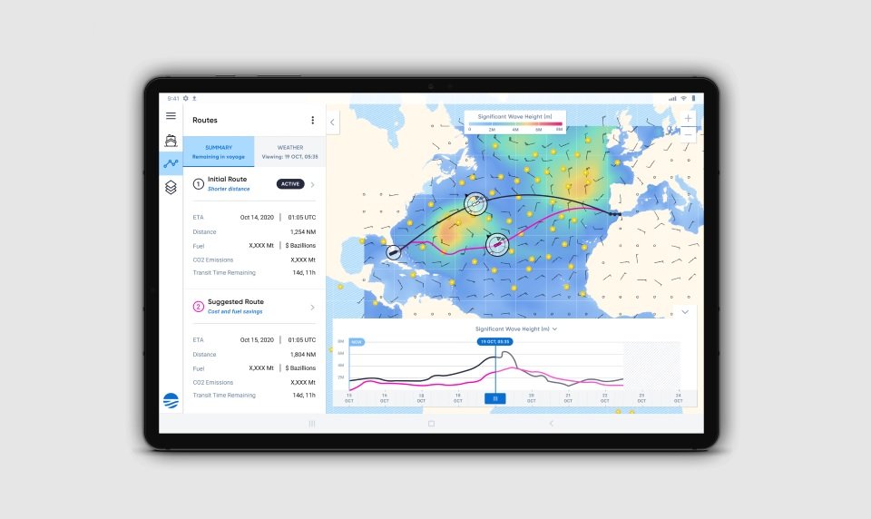
Sofar’s proprietary open ocean sensor network and weather forecasts, combined with real-time market variables and personalized vessel performance models, deliver high-accuracy weather routing and daily speed and routing guidance to ensure more efficient and safer routes.
Optimized voyage and speed profiles can produce massive reductions of greenhouse gas emissions according to the International Maritime Organization. According to the IMO, with voyage optimization you can see anywhere from 1-10% reduction in GHG. With today’s optimization solutions there is no concept of continuous weather monitoring and daily updates to ensure that ships are always on the most optimal path. Wayfinder’s unique value is that it’s powered by the best weather data with continuously optimized routing recommendations. This gives fleet operators and captains the most recent weather and routing context they need to maximize voyage profitability, minimize safety risks, and track closer toward carbon neutrality with each transit.
Several major commercial shipping companies including Singapore-based Berge Bulk, Greece-based Star Bulk and Seaven as well as U.S.-based Class society ABS are leveraging the new technology to streamline fleet efficiency by identifying more direct, cost-effective, and energy-efficient routes.
As a pioneer in shipping sustainability, Berge Bulk has aggressively pursued decarbonization strategies over the last decade. In support of this initiative, they were one of the first pilot customers of the Wayfinder platform. According to their CEO, James Marshall, “Wayfinder allows us to increase vessel utilization and efficiency, ensuring that we balance profitability with emissions reduction objectives. By using Wayfinder’s data and voyage optimization, we’ve seen
efficiency gains in the range of 4.5% on dedicated voyages, which translates into as many as 14 additional sailing days per year per vessel.”
“Wayfinder is the Google Maps or Waze of the ocean. It’s your voyage partner — always looking out for the best options among the trillions of possible routes in the ocean,” said Tim Janssen, CEO and cofounder of Sofar Ocean. “Like navigation apps on land, Wayfinder integrates seamlessly into the captain’s workflow and is easy to use. It constantly updates its recommendations based on the latest weather data powered by thousands of live weather sensors, variations in the bunker and charter market, and vessel performance dynamics. Ocean intelligence is in our team’s DNA, and Wayfinder is a big step toward our mission of building a more connected ocean.”